


70mph gales to batter Highlands on Christmas Eve and into Christmas Day, warns Met Office
Register for free to read more of the latest local news. It's easy and will only take a moment.

Christmas will start windy and wet, Highlanders have been warned after separate alerts for gales of up to 70mph and heavy rain were issued by the Met Office.
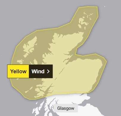
Gusts of up to 70mph are possible on Christmas Eve and into the early hours of Christmas Day in the north of Scotland.
The yellow weather warning comes into force at midday on Christmas Eve and will remain in place until 3am on Christmas Day.
It covers an area stretching from Mull, Oban, Perth and Dundee in the south and up across the entire north of Scotland bar Shetland.
Related: Snow and ice warning issued for Christmas getaway
Fifty mph winds are predicted "widely", and guests of up to 70mph are possible across Sutherland, Caithness, Lewis and Orkney. Areas to the east of high ground will be particularly susceptible to the gusts.
A Met Office spokesperson said: "An area of low pressure passing to the north of Scotland brings the likelihood of strong winds to much of northern Scotland on Sunday and early on Monday.
"Winds will initially increase across the northwest of the country before transferring east through the day.
"Gusts of 50mph are likely quite widely, but there is potential for gusts as high as 60 or 70mph across Lewis, Orkney, Sutherland and Caithness. Some very gusty conditions are possible to the east of high ground."
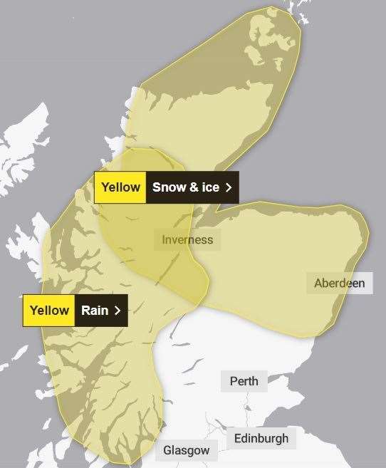
A separate yellow warning for rain has also been issued for western and central Highland areas for almost all of Saturday, December 23.
This rain warning comes into force at midnight tonight (Friday) and runs until 11.45pm on Saturday.
The area covered extends from the Coigach peninsula and the northern shore of Loch Shin in the north, and south through Sutherland, most of Ross-shire except Invergordon and Tain, the Black Isle, Inverness, Loch Ness, Monadhliath Mountains, Fort William, Oban and as far south as the Cowal peninsula, Bute, and the northern end of the Kintyre peninsula.
It also extends west as far as the Ardnamurchan Lighthouse, eastern Rum and central and eastern Skye.
Most areas are expected to see up to 50mm of rain, with up to 100mm possible on the higher ground.
The Met Office spokesperson added: "A slow-moving weather front is expected to lead to a period of heavy rain developing this weekend.
"Rain is expected to begin on Friday evening, continuing through Saturday before easing early on Sunday. Many places are expected to see 20-50 mm however across the high ground totals of 80 to 100 mm seem likely.
"The first half of Saturday is also likely to see some snow over northern parts of the region, covered in a separate warning, before it turns to rain."
The rain alert overlaps some areas covered by an existing yellow warning for snow and ice, which was issued yesterday and will be in force from 9pm on Friday night until midday on Saturday.