


Snow and ice warning issued for Christmas getaway
Register for free to read more of the latest local news. It's easy and will only take a moment.

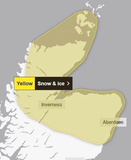
A snow and ice warning has been issued for the Highlands heading into the weekend as folk begin their Christmas getaway.
The region's roads are expected to be busiest Friday into Saturday as people head home or to relatives for the festive season.
And a yellow warning will now be in place during that busy period after the Met Office issued a warning for up to 15cm of snowfall in parts of the Highlands – and up to 5cm even to lower levels.
The warning comes into force on Friday evening at 9pm and will remain in place until midday on Saturday.
Related: Storm Pia leaves hundreds of homes without power across the Highlands and Islands
The alert extends across much of Orkney and southwards into all of Caithness and most of Sutherland and Ross-shire apart from the far west. The alert also covers the Black Isle, Inverness, Loch Ness, Nairn-shire, Moray, Aberdeenshire and as far south as the Drumochter Pass and the northern Angus glens.
A Met Office spokesperson said: "Snow is expected to develop across north and northeast Scotland during Friday night before gradually turning to rain during Saturday.
"Initially, snow will be reserved for hills above around 200 metres, but through the night snow is likely to fall to lower levels for a time.
"With cold air slowly being replaced by milder air from the southwest, there is some uncertainty in accumulations across the warning area. However, some low-level locations may see 2-5cm, whilst accumulations of 10-15cm are likely to be reserved for higher ground above around 200 metres.
"An additional albeit temporary hazard will be the chance of ice mainly over higher ground as snow turns to rain."