


Overnight frosts to hit much of the UK, Met Office says
Register for free to read more of the latest local news. It's easy and will only take a moment.
Overnight frosts are set to hit much of the UK this week as a blast of cold air brings freezing temperatures, forecasters have warned.
Widespread overnight frosts are possible and snow could fall in northern Scotland and parts of north-east England as the UK sits in the grip of cold northern Scandinavian air, the Met Office said.
It means a cold chill may bite through to the start of next week as daytime temperatures struggle to get above single digits and overnight temperatures stay below freezing for much of the country.
Met Office chief meteorologist Neil Armstrong said: “There has been some uncertainty in the atmospheric weather patterns for the coming days, however, confidence in the forecast is improving and there is a reducing chance of snow for southern areas of the UK, although there is still a chance we may see some sleety wintry showers over higher ground in areas such as Dartmoor or Exmoor.
“Northern and north-eastern areas of the UK in the moist north / north-easterly airflow continue to see a chance of snow or sleet.”
Britons are being told to brace for potentially “hazardous conditions” as snow and ice are set for parts of the country.
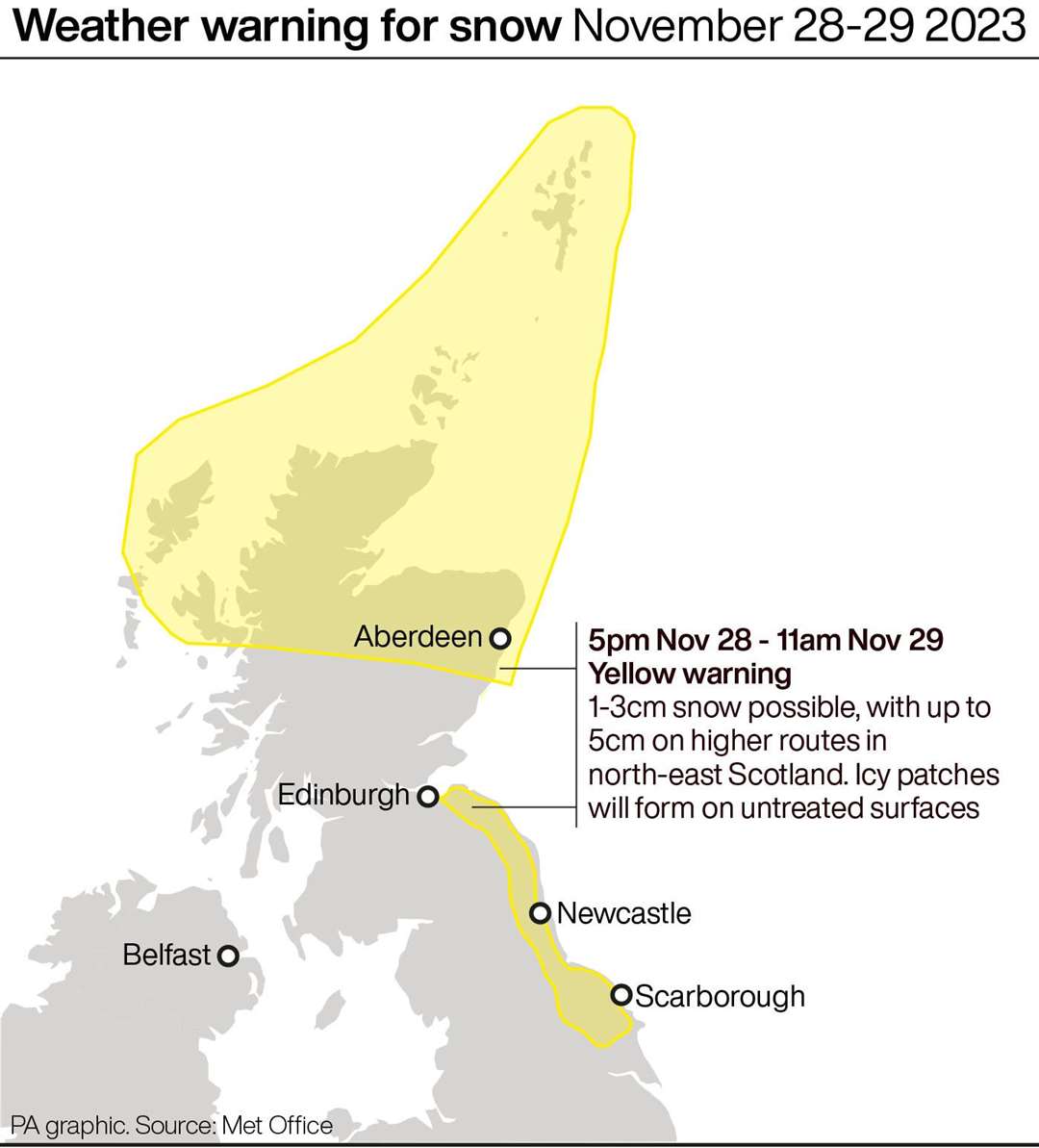
The Met Office has issued yellow weather warnings for snow and ice from 5pm on Tuesday until 11am on Wednesday for parts of northern and eastern Scotland, north-east England and Yorkshire.
A separate warning is also in place from 5pm on Wednesday until 11am on Thursday for eastern Scotland and north-east England down to North Yorkshire.
The Met Office said: “Wintry showers will lead to ice forming on untreated surfaces during Tuesday evening and overnight into Wednesday morning.
“Snow will begin to accumulate, especially away from windward coasts, with 1-3cm possible. Higher routes of north-east Scotland may see up to 5cm of snow accumulate.”
Up to 2cm of snow is possible in places overnight from Wednesday into Thursday, with 5cm over higher ground.
It is likely that some roads and railways could be hit, meaning travellers could face longer journey times by road, bus and train, according to the forecaster.
They also warned that some icy patches could form on untreated roads, pavements and cycle paths.
The UK Health Security Agency (UKHSA) has issued a yellow cold-health alert for the health sector covering northern regions of England which runs to December 5.
The Met Office said the cold spell is likely to continue into next week but many places will see dry, sunny weather while wintry conditions and showers could particularly hit eastern coastal areas.
The forecaster explained that snowfall in late autumn or early winter does not generally linger – especially in southern Britain – as ground temperatures broadly remain relatively high after the summer.
RAC Breakdown spokesman Rod Dennis said the service is expecting to see “a sharp rise in breakdowns this week” as the nation is in the grip of the cold blast and car batteries falter.
He urged drivers to get their cars checked and to bring some winter gear on their journeys in case they get stuck in sub-zero temperatures.