


Further wild weather forecast tonight
Register for free to read more of the latest local news. It's easy and will only take a moment.


WIND battered communities are bracing themselves for more wild weather overnight.
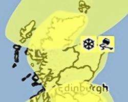
Another Met Office weather warning for strong winds comes into force just after midnight - with forecasters warning of winds of up to 90mph in parts of northern Scotland, and 70mph in the local area.
The new warning comes just hours after an earlier storm system hammered the north of Scotland, with wind speeds of more than 100mph being recorded in several locations, and hurricane-force gusts of 140mph registered on Cairngorm.
The violent winds caused massive disruption, knocking off power to thousands of homes, causing structural damage to a Premier Inn in Inverness, felling numerous trees, closing road bridges and sparking the mass cancellation of all Scotrail services while lines were inspected for damage.
At the time of writing power had still not been restored to many homes, including some on the Black Isle.
The new storm warning comes into force at 12.05am in the morning and lasts for most of Saturday.
"Another very vigorous depression is likely to run quickly eastwards, passing to the north of Scotland on Saturday. Gusts of 50-70 mph are likely over the mainland," said a Met Office spokesman.
"The public should be aware of the risk of disruption to both transport and power supplies, as well as the risk of some structural damage. Large waves may lead to dangerous conditions along some coasts.
"The winds should gradually ease from the west later in the day," they added.
A third Met Office weather warning is also in force for snow and ice across the north of Scotland, with frequent heavy snow showers forecast even to low levels.
The snow warning comes into effect at 6am on Saturday and run until midday on Sunday.
The Met Office spokesman added: "A cold front will introduce a strong, cold northwesterly airstream on Saturday which will bring showers across many northern and western regions, some of which will be heavy.
"Showers will fall as sleet or snow to low levels in the north and over high ground further south within the warning area. Icy conditions are also likely on some roads, particularly as rain clears early on Saturday over northern Scotland.
"Snow showers will also be accompanied by strong or very strong winds and this may bring temporary blizzard conditions over higher ground, leading to difficult driving conditions on higher routes."
http://www.metoffice.gov.uk/public/weather/warnings