


Waterfall walk with a twisty return
Register for free to read more of the latest local news. It's easy and will only take a moment.

On a recent visit to Gairloch, we decided to make the most of one of those rare but memorable days on the west coast.
The mountains were bathed in sunshine and, although it was still pretty cold, it was perfect for a walk we’d had our eye on.
Meg and I have spent weekends camping in Wester Ross in the past, but this time we were just here for the day to take our baby Clara to what I consider one of the most beautiful parts of the Highlands.
This waymarked circuit begins at the southern end of Gairloch, at Charlestown opposite the harbour. There are car parks on both sides of the road, and on the harbour side there’s a well stocked shop as well as public toilets further along at the harbour itself.
Once we’d wrapped Clara up to keep out the cold, we set off, crossing the main road from the harbour side and passing an old stone bridge that leads to the inn on your right. Just past the bridge, a sign marked “Flowerdale Waterfall Footpath” points right, onto a path.
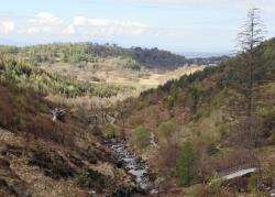
The route follows a delightful well-made path, passing a pond and a number of impressive old trees, which were just coming into leaf on our visit.
Keep straight on at a wooden sign beside the wall, following the red waterfall route rather than the green circular.
Soon after the path bends right down a tree-lined avenue, a small red marker indicates a left turn. A curious sign explains that the estate could only raise enough funding to properly surface the path to the bridge just beyond the gate, but suggests the rest of the way is “navigable” by wheelchairs and buggies.
Having pushed Clara’s buggy around various off-road walks, I’m not convinced it would have been a comfortable ride beyond here, and we were glad we had taken our little rucksack to carry her in this time.
Over the bridge, the path is still really good for walkers as it twists and turns to follow the Abhainn Ghlas upstream higher into the glen. Where it emerges at a track, go left to cross the burn then immediately right to follow the burn more closely.
This path meets a track from Flowerdale Mains and you continue right as the red marker confirms. As the track gets higher, ignore any turn-offs and keep straight ahead, occasionally catching a glimpse of the waterfall further on.
The way ahead rises gently to reach a large wooden bridge, built by the army in 1993. There’s a beautiful view of the falls from here but the path up to them is eroded and very steep in places, passing under boughs of trees which Meg had to duck carefully under with Clara on her back.
We had a nice picnic break at the top, enjoying a superb view over Loch Gairloch and out into the Atlantic past Longa Island.
As we headed the short distance to the next bridge, the rocky peak of An Groban dominated the skyline. At only 383m it is a small hill but looks like it would make a fantastic outing on another day.
For our route, we crossed the bridge and turned to the right, back on ourselves so that we were now walking towards that magnificent view. On this return route, you are much higher than on the ascent, so it means you can really appreciate the scenery more.
The path, now excellent quality again, descends through young trees and heather with high cliffs up to the left, crossing a number of small bridges on its way and dropping through a steep S-bend at one point.
Just before reaching a forest track, there is a memorial to Ian Dall Mackay, the blind piper of Gairloch, who lived in the 17th century and is still held as one of Scotland’s greatest pipe composers.
Go left at the junction, now joining the blue markers for the rest of the way. Follow the track as it climbs around the side of the hill, turning right over a small bridge some distance on. The bridge is marked by a blue post and these markers continue through the woods on a boggy and narrow path.
This interesting section of the route provides some lovely views over the glen as you descend – through a few tricky bits of path in places, definitely not buggy friendly now – and finally reach another track. Turn left onto this, then about 10 yards further on go right, up into the woods, where you’ll be reassured you’re on the right path when the blue markers return.
This pretty woodland trek is really a bit of a detour, as you end up back on the track further along, but it’s worth taking to enjoy the twisty path and to get a good view of the impressive Flowerdale House.
Turn right back onto the track then stay right after a gate to reach a junction with two high gates on the track ahead. Go through both gates to keep to the left fork, rather than following the other track which leads to the house.
Soon you pass through an old hand gate to reach the Old Inn a few yards further ahead.
We popped in for a quick cuppa before crossing the stone bridge to reach the car park after this lovely walk.