


Walking back into the depths of time at Dunbeath
Register for free to read more of the latest local news. It's easy and will only take a moment.

WALKING ROUTE
Dunbeath Strath
Distance – 3.5 miles shorter circular route; 7.5 miles total for the full route
Terrain – Riverside path, vehicle track, minor road, pathless boggy hillside
Maps – OS Landranger 17
Start/finish – Dunbeath Old Mill
Feeling spooked on a historic trail deep into a Caithness strath
Following the Dunbeath Water, this unofficial heritage trail takes you years back into history and miles into the depths of the strath.
It’s a fantastic walk along the riverside, through gorgeous hazel woods and visiting a number of ancient sites, including one of the best preserved brochs in Caithness.
In my experience it’s also quite an eerie experience, especially if you decide to continue beyond the “Prisoner’s Leap” and deeper into the remote hills, where there’s a walled cemetery and a series of ruined chambered cairns.
This part of the route follows a rarely visited track and crosses some seriously boggy, pathless mountain terrain. I was glad I’d brought my full walking gear, including sticks, boots and gaiters.
The circular route as far as the gorge is not so arduous, and follows well-defined paths and a stretch of minor road on the return.
It begins at a car park and picnic area behind the old Meal Mill just north of the Thomas Telford bridge, which once carried the A9 over the river and through the village. An information panel at the start of the walk shows you some of the highlights ahead on this fascinating outing.
You don’t have to wait long to find them, either, as you stroll along a delightful section of narrow path and soon come across the Chapel Hill, believed to be the site of an ancient monastery with its large walls protruding from a central mound.
I exchanged a wave with a local crofter tending the land around the “House of Peace” as it is also known.
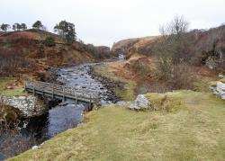
A great suspension bridge crosses the Houstry Burn and, immediately the other side of it, go through the little wooden gate and up the eroded path to find the Dunbeath broch. It’s surrounded by a modern wall to keep livestock out, though the gate was rotted off its hinges when I got here, leaving it exposed anyway.
I entered the enclosure and had a look around the broch, with its walls still standing fairly high and one of the chambers still accessible at the far end. Being on my own, I didn’t fancy crawling into this dark vestibule, so just poked my head around the opening before making my way back to the gate beside the bridge.
There are good views back towards the Telford bridge, slightly spoiled these days by the modern A9 flyover, and I headed back to the suspension bridge, where a right turn continues the trail along the riverside.
Keep straight ahead where you pass a rickety bridge and notice the old ruin on the opposite bank – once the old inn for the village, and according to the interesting Dunbeath Heritage Centre, there were many village celebrations held on the nearby “picnic green”.
Now you pass through beautiful woods, where hazels, rowans and birch trees laced with lichens dominate this wonderful area.
At one point the path rises away from the river and passes a bench before dropping down to another bridge.
Ahead lies an impressive gorge known as the Prisoner’s Leap, across which Ian McMormack Gunn is said to have leapt to his freedom having been imprisoned in nearby Forse Castle by the Keiths.
Having continued past the bridge and headed up a fairly obvious path up the steep slopes to the right before reaching the gorge itself, I continued to a fence above the gorge and decided it was an unlikely story.
The walk here has dangerously steep drops and anyone not comfortable with pathless and energy-sapping terrain should head over the bridge and continue on the return route.
For those willing to tackle the rest of the excursion, it looks a long way from here to the top of Cnoc na Maranaich, easily identified due to the large cairn and standing stones at its 172m summit, but a good track makes some of the going a little quicker. To reach the track, turn right when you reach the fence above the gorge and follow the edge of the field. Turn left onto the track, going through an opening beside a gate.
The vehicle track leads to Loedebest, where a ruined farmhouse sits in this idyllic – if rather spooky – location near some chambered cairns. Further along the track lies the Tutnaguail cemetery, still in use today, and surrounded by whitewashed walls. It lies miles from any civilisation and I was glad to only hear some of the ghostly stories about this place after I’d returned home!
From the cemetery, make a beeline across the rough moorland to the summit of Cnoc na Maranaich, watching out for the boggy rivers and tussocky ground. This is where the walking sticks really made life a little easier than it would have been, especially as I was quite eager to keep my distance from the
eerie cemetery behind me.
The hill steepens just before the top, guarded by local ravens as I approached; then I was there, clambering to the summit past a standing stone that is said to have aligned with the setting sun and a notch in the hills in the west on midsummer’s eve around 2000BC when it was in use. There is also a chambered burial cairn here.
From here you can return to the cemetery or, as I did, find your way back to Loedebest across the rough moors. There is a very old track running roughly south-east from just below the summit, though I was three-quarters of the way down before I actually found it! The compass came in useful here but eventually I was able to aim for Carn Liath, a ruined chambered cairn similar to the Long Cairn at Camster but with a modern stack of stones added on top.
From the cairn I cut back to the track beside the ruined farmhouse and headed back to the far side of the Prisoner’s Leap. This would be a beautiful spot for a picnic in summer, and I stopped briefly for a bite to eat and was rewarded with the sight of a buzzard which was clearly used to the solitude.
The heritage trail suggests returning the same way to the mill, but I decided to make a circular route by crossing this bridge and heading up the wonderful path through more lichen-covered trees, keeping left at one point where the path forks.
Looking back, I could see in the distance the standing stone and cairn on top of Cnoc na Maranaich beyond the gorge.
Emerging from the woods, the path soon reaches a minor road, which you turn left on to and follow back towards Dunbeath. After crossing the Black Water, take the first road on the left and follow it all the way down to the end of the road, where a gate leads onto a rather muddy track.
There were Highland cattle in the open field but they kept their distance as I followed the track downhill to the grassy area beside the ruined inn I had passed on the opposite bank earlier. Cut off across the grass to the rickety bridge and cross it with care – if you dare!
A previous bridge was washed away in floods in 2006 and this replacement was built the following year, but a sign from the estate warns you that you cross at your own risk. If you don’t mind a bit of movement, it seems okay, but I made sure I kept my feet across two planks of wood at the same time, as they had a bit of flex in them!
Turn right and follow the last short section across the Houstry Burn and back to the old mill to conclude this fascinating trip into the past of one of Caithness’s most intriguing straths.