


Trail by the sea holds no secrets for walkers
Register for free to read more of the latest local news. It's easy and will only take a moment.

WALKING ROUTE
Moray Coast Trail
Distance – 7 miles
Terrain – paths and tracks, well signposted route
Start/finish – Findhorn/Burghead, Moray
Maps – Outline maps available at www.morayways.org.uk/moray-coast-trail.asp; Rucksack Readers guide, Moray Coast Trail by Sandra Bardwell, also available
A flat walk along the edge of the dramatic Burghead Bay
As we turned the corner, a wall of heavy snow greeted us and the road went from black to pure white in seconds. And that was just on the way to this fabulous walk.
We dropped my car at Burghead, wondering if it would be buried under the white stuff by the time we had walked the seven-mile coastal route back here from Findhorn.
I hopped into Peter’s car and we drove back to the start at Findhorn, where bizarrely it was glorious sunshine as we set off from the car park amongst the dunes by the beach.
Following the road back towards the village, we turned left at a wooden sign pointing to Burghead that led along a short track and into the dunes.
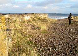
The sea itself was out of sight but as we got nearer the shore we decided to cut off the track which the route officially follows and walk on top of the parallel sea wall.
From the dunes at Findhorn we could now see over the Moray Firth to the lighthouse at Tarbat Ness and the snow-covered hills of Sutherland. There was a definite chill in the air despite the sunshine and we had to be well togged up for this trek along the length of the exposed Burghead Bay.
We kept an eye out along the track for the wooden marker posts which are dotted along the whole of the Moray Coast Trail, a route which stretches 44 miles from Forres to Cullen.
After the route goes past another beach car park, it begins to turn slightly inland, so we came off our sea wall detour and stuck more rigidly to the signs, which soon guided us through some nice little forested areas towards a set of three wind turbines that power the small community at Findhorn.
Further on we came across a fallen signpost at a crossroad of paths. Between us, Peter and I attempted to stand it up again and point it in the right direction but it wasn’t for staying in the ground; it looks like it’s in need of some foundations to keep it in place.
However, the way ahead was clear enough and we continued until a fork in the track a little further ahead, where we veered left to meet the shore again.
A rather serious sign greeted us at the corner of a fence, warning passers-by to stay out of the base at RAF Kinloss, a place which has been much in the headlines recently.
The sign tells people in no uncertain terms that entering the base is against the Official Secrets Act.
Continue to follow the shoreline here along an ever-decreasing gap between the base and the eroding sandy cliffs being battered by the sea day after day. There is evidence of old tracks which now just end at the edge of the fragile cliffs, but a clear path is easy to follow all the way to the forest ahead.
Across the wild, open bay we could see Burghead on its narrow jut of land, sticking out into the North Sea without any fear. It was bathed in sunshine now, too, a far cry from the wintry shower we had driven through earlier in the day.
We decided to stop for lunch and enjoy the view across the firth from here before entering the shelter of the trees.
The way through the forest is clearly marked, staying close to the sea initially before turning inland on the main forest track.
That’s almost the last you see of the sea until the end of the walk, but we were pleased to see how busy the delightful Roseisle Forest was on a chilly weekend in December.
There are a number of shorter forest walks marked here, as well as the Moray Coast Trail going through the entire length of the forest, so it’s a popular spot with families as well as more serious walkers.
We discovered a nice little bird-watching hide and, even though the feeders were mostly empty, there were still some determined birds searching for the last scraps of food on this cold day.
We chatted to a couple of gentlemen from the local Ramblers group at the main forest car park before heading straight on along a good path, busy with walkers of all ages.
From here it was a delightful trek through the pine forest to Burghead, where the route emerges at a caravan park.
Go through the gate and follow the road through the site (keeping left at first) then, once you’re past the caravans, turn left towards the harbour.
As we reached the car, there was no sign of the snow from the morning. This dramatic bay had shown itself to be varied in weather and character, giving us a fantastic walk and a great taste of the longer trail.
?