


Tracing the canal for a taste of the Great Glen wonders
Register for free to read more of the latest local news. It's easy and will only take a moment.

BIKING ROUTE
CALEDONIAN CANAL LOOP
Distance — 14 miles
Maps — OS Landranger 26
Start/finish — Tomnahurich Bridge
A flat and largely traffic-free ride full of fun around the Highland Capital
I’VE had cause to go to Dochgarroch on a number of occasions recently — for kayaking, running and cycling — and it reminded me what a lovely spot it is to get to.
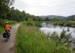
The towpath down to the lock gate is a popular local route, and I’ve seen loads of people out and about, taking in the wonderful scenery down the Great Glen.
Whether you’re a Highland resident or a visitor to the area, this fabulous canal-side stretch is well worth seeing.
This 14-mile cycle circuit — most of which is traffic-free — can be done in one go from anywhere along the route or, by starting at Tomnahurich Bridge like I did, you could even split it into two shorter routes. There’s plenty of car parking in this area beside the rugby pitches or at Whin Park.
I headed off in the chill air of an early summer morning but it looked like it would be a fine day ahead. Going through the rugby pitch car park, a small grassy track heads up towards Tomnahurich Bridge and joins the towpath just before it.
Go left onto the towpath, which is a fairly wide, well-made track for the three-and-a-half miles to Dochgarroch. Passing through a gate, you soon pass above a weir then a path from Whin Park joins from the left.
Keep going, enjoying a brief view down to the River Ness on your left before the trees block the view in that direction.
As you go further, you see the cattery and kennels on the far side of the canal and the view ahead becomes wilder and greener down the Great Glen. Look out for Dunain Hill on your right — the one with the communications masts — and further on the lump of Meall Fuar-mhonaidh beyond Drumnadrochit can be seen in the distance.
During these summer months you are likely to see some traffic on the canal, and there is wonderful wildlife to be spotted at all times of day down here too. I’ve even enjoyed running with bats darting about at dusk along the towpath before. It’s a wonderful place to come to.
Soon you’ll notice the boats moored on the opposite bank, telling you you’re almost at Dochgarroch lock.
There’s a grassy picnic area on this side of the canal, and it’s worth carrying on to the end of the path on this side before crossing. Right at the end of this grassy stretch there’s a large weir with signs telling boat traffic to keep right for Loch Dochfour. You can also cut through the trees on a short path to the river, which runs parallel to the canal.
Return to the picnic area and cross the canal at the lock, heading back up the tarmac road past the moored boats towards Inverness again.
Beyond the "Road Closed" sign, instead of following the canal path right, go left of the fence along a narrow path. It can be bumpy along here but it’s not too bad to ride along the obvious line through the grass and alongside a fenced forest area.
This leads to a rough vehicle track which you keep straight on at, to eventually meet a smoother track. This one leads past a couple of large fields — with fabulous open views — to a junction. Turn right to go past a couple of houses and, where you seem to run out of road, veer right down a gravel slope alongside a hedge to meet the towpath beside the cattery.
Follow the canal back to Tomnahurich Bridge and cross the A82 carefully to continue on the left bank of the canal past the caravan park.
Where the tarmac stretch curves left, keep straight ahead onto a new path and follow the edge of the canal until you have to go left to bypass a house. Where this narrow path emerges, go carefully through the marina to Muirtown Locks, where there’s a bike shop on the left, then follow Canal Road down over a number of speed bumps to the traffic lights.
Cross by the swing bridge here and go through the black metal gate onto the path which skirts round the wide and impressive Muirtown basin.
Follow the path to the level crossing, then continue the other side to the sea lock on the edge of the Beauly Firth. This is an amazing spot with views over Beinn a Bha’ach Ard — the triangular hill visible to the west — and Ben Wyvis over the Black Isle to the north.
Cross at the lock and return up the far side, going over another level crossing then past the joinery works. Just after a gate, turn left back on yourself down a steep slope signed to South Kessock pier. This path heads dead straight, crosses the railway again, then continues along the sea wall to the old ferry.
I spotted a family of roe deer down here in the Merkinch Local Nature Reserve when I was doing this route. You can also see many wading birds, especially at low tide when the mud flats are exposed.
When you reach the turning circle, where there are more picnic benches, go right and follow the road, enjoying a spectacular view of the Kessock Bridge from the mouth of the river.
Go left just before the Spar shop and pass the Gael Force Marine store and new flats then continue straight ahead until you pass under the railway bridge and reach the end of the road. Cross the road here and continue straight on, with the river still on your left.
Where the road sweeps right, a cycle path turns left beside a large tree to go under the Friar’s Bridge and onto Huntly Place. Keep going along the river to the traffic lights then go straight on. At the give way sign, turn left past the cathedral and Eden Court then go left again to stay beside the river.
Keep going all the way past the Ness Islands and the archive centre then follow the road right past Whin Park to return to the rugby pitches.