


Topping out on the edge of Affric
Register for free to read more of the latest local news. It's easy and will only take a moment.

FIFTY more yards and we would have made the summit. That was more than six years ago now, and I laughed as I realised just how close we had been.
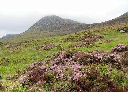
It was early spring 2008, not long after I had moved to the Highlands, and my girlfriend Meg – now my wife – and I had come to Glen Affric to climb these two Munros by a rather circuitous route, which ended with her falling waist deep into a bog... but that’s a different story.
We’d made our way up Toll Creagach and over to the west top of Tom a’Choinich before descending to the Bealach Toll Easa. From here it’s a short but sharp climb up to the 1112m summit. We were there without ice-axe and crampons but the rocky ridge with patchy snow and ice was making us think we might need them for this last stretch, and mist was clouding our view of what lay ahead. After a quick recce, we reckoned retreat would be the safest option on this occasion.
When I returned to these hills a couple of weeks ago, this time with Peter, we took a more popular route, following the track from the Chisholm Bridge then the soggy stalkers’ path up towards the bealach before veering left onto Tom a’ Choinich’s south-east ridge.
Mist clung resolutely to the slopes despite the forecast suggesting an 80 per cent chance of cloud-free Munros, so we were soon in the clouds, gaining height rapidly on an interesting if straightforward spur.
After the rocky section of ridge ended it seemed to take an age to reach the obvious summit cairn across easier ground. Peter finally spotted it through the veil of mist and we hunkered down for our first proper stop of the day; the midges had been too numerous down in the glen to pause for more than a few seconds but the wind was stronger up here and kept them well away.
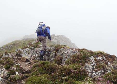
Double checking our angle of descent with a compass bearing, we made for a rusty fence post where the land dropped away. This east ridge drops to the Bealach Toll Easa, looking fairly committing and narrow at first glance, though after the first few steps it eases significantly.
As we reached the last of the simple scrambling, I looked back and said to Peter: “If that’s the last of the rocky section, this is where I got to last time!” We weren’t far down the ridge at all, but you have to make a decision based on the information available at the time.
These days I might have checked my position using GPS to see how much further the ridge went. Used as an additional tool to the necessary paper map and compass, I find my GPS unit – an app on my smartphone with full OS Landranger series background loaded onto the memory card – invaluable in the hills.
From the bealach the plan was to go over the west top of Tom a’ Choinich and continue across the ridge towards the second Munro, Toll Creagach, but an obvious path led us below the top before we noticed we were losing height. Still in the mist we checked our position and made for the higher ground to our left, then took a bearing through the clinging cloud across a plateau area.
After dropping a short distance to a bealach below the summit we began the final ascent, still following a rough bearing towards the summit cairn and trig point, where we found the remains of a shelter that was no longer serving much purpose. Still, we tucked down and enjoyed a bite to eat before planning our descent.
The wind blew the top clear briefly, giving us a temporary view of Glen Affric to the west and Glen Cannich to the north.
Wanting to avoid the sodden and neglected stalkers’ path that we had followed from the end of the track into Gleann nam Fiadh, Peter suggested continuing east to a low bealach then cutting down steep slopes to meet another track near the bottom of the Allt Coire an t-Sneachda.
We’d lose 250m in height following the ridge before having to cut down steep pathless slopes, so I was happy to follow this suggestion.
The descent was rough but manageable and our main problem was near the bottom where a new deer fence – not marked on the map – presented itself.
We opted to stay outside the enclosure and follow the fence line left, cutting across deer tracks at the bottom to meet the track.
Looking back up the slope, it would have been just as easy to stay right of the fence and drop down a steep but manageable slope to the track.
Once there, it offered a clear route back to Gleann nam Fiadh, but I’ve never seen so many established water features on a track! We had a few detours to keep our feet dry, though the rain was on now as we made our way back to the outward track.
Going left at the junction, we kept our fingers crossed that the midges would have been and gone by now. It wasn’t to be our day in that respect but at least I’d conquered a summit that had beaten me on that first visit.