


The trails where forest and sea meet
Register for free to read more of the latest local news. It's easy and will only take a moment.

BIKING ROUTE
CULBIN FOREST CYCLE TRAIL
Distance — 13 miles
Maps — Forestry Commission leaflet, Culbin Forest (available at car park or see my website www.BL6.co.uk for link to on-line version)
Start/finish — Cloddymoss car park
Miles of glorious traffic-free trails to explore and enjoy.
It’s a wonderful place to get lost." The casual conversation I had with a lady as we admired the view over Findhorn Bay bathed in sunshine really summed up Culbin.
There are so many tracks and trails in this stretch of unique planted woodland that you could easily lose where you are — if it wasn’t for the Forestry Commission’s numbered junctions and excellent little trailmap.
This route takes you from Cloddymoss, near Brodie, right over to Findhorn Bay, but the beauty of Culbin is also that you can choose to venture as far or as near as you like.
The wildlife here is phenomenal too, and if I were an ornithologist I would be able to list a huge number of species I saw and heard on this one outing — but, alas, I have to be honest and admit I couldn’t tell you what most of them were. To me, it’s just a great pleasure to be riding through this forest teeming with life, whether you’ve got half-an-hour or all day to savour this spectacular place.
To reach the Cloddymoss car park, leave the A96 at Brodie Countryfare then head straight on after the level crossing, following signs for Cloddymoss right at a T-junction then left further down the road. As this road reaches some houses, bear left into the forest then keep right at a turn in the forest track to reach the parking area, where there is a huge notice board with a map, and a small box of leaflets.
After waiting for a heavy shower to pass, I got on the bike and continued down the track through an open gate into the forest. This first part had undergone some forestry work recently and was a bit muddy, but I can’t help but love that smell of freshly sawn timber — and the mess was soon left behind as the track improved beyond junction 33.
At a fork, bear right (junction 34) then continue past junction 35. The track goes through a younger area of forest, which you turn right in the middle of at an unmarked junction and continue to the "Hidden History" — a place which explains how the village of Culbin was buried under the sand in a storm before the dunes were forested.
Take a left here, heading for The Gut, and continue through junction 16 to 15 on a slightly rougher track, though all of the marked tracks in the forest are superb for cycling.
From this point, I wanted to stay as close to the shore as possible as I made my way through the trees. I turned right to head along the excellent track which twists and turns until junction 14, where you stay left to continue in an easterly direction.
A short way ahead, I detoured left up a grassy track to The Gut — an area of the RSPB nature reserve made up of salt, sand and shingle, perfect for wading birds at low tide. You can look out across the water and tidal muds from the very edge of the forest, and a bench here offers the perfect viewing platform.
Returning to the main track, I turned left to continue east. The nature of the forest seemed to change along here and I couldn’t believe my eyes when I saw a blanket of "moss" stretched out below the trees like light green snow. These delicate lichens grow incredibly slowly and in this undisturbed habitat look remarkable.
At junction 13, take a left and follow the track round as it curves to the right. You can sense the proximity of the sea here and there’s quite an eerie area of bare trees between the track and the high tide mark. At the end of these trees, the view to the left opens up and there are fantastic sandy beaches at Buckie Loch. I followed the sign down to a picnic area at the beach’s edge and dropped the bike as I went for a stroll out onto the golden sand.
What an amazing place! I’m not usually a fan of sandy beaches but this was fantastic. I got back on the bike and continued along the track, staying left at junction 5 then, at a sign at junction 3, headed left towards Findhorn Bay.
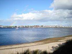
This track bends left through the trees then emerges at an open area overlooking the delightful bay. Again, I left the bike on the track and plodded down to the water’s edge, enjoying superb views over to the village, bathed, as it was, in sunshine, with a part rainbow the perfect backdrop.
Back at junction 3, I headed towards "Lady Culbin’s Trees", taking a right turn down the hill at junction 4. Lady Culbin is the name of one of the dune systems in the forest, and the trees are buried deep in the sand, some even tapering down towards the roots, so they are like the tip of a pencil. One such example has been dug out and is visible from the track.
It’s a long stretch to the next turn at junction 2, where you bear left. Watch out for more walkers around here, as you are near the Wellhill car park, the busiest at Culbin. Continue ahead at junction 43 — ignoring the sign to the car park — and then straight on again at 42.
At the next junction, 37, go left onto a grassy track then right at 36. The track skirts by the edge of a farming field before reaching your outward route at junction 33 near a muddy patch of that forestry work. Go left to return to the car park at Cloddymoss after a wonderful journey exploring this magnificent forest.