


Tested and inspired on long distance Highland treks
Register for free to read more of the latest local news. It's easy and will only take a moment.

SCOTLAND'S most popular long-distance path, the West Highland Way, takes walkers from Milngavie on the outskirts of Glasgow to Fort William in Lochaber.
It’s a route I walked eight years ago, but since then I’ve discovered there are lots more options for multi-day treks right here in the Highlands and Islands.
I’ve done bits of just about all these trails, and one or two of them in full. Some are well-marked trails with plenty of B&Bs or campsites for accommodation; others are wilder adventures through rough terrain with little habitation for miles.
This latter type tend to only exist in the imagination of enthusiastic walkers, devised as a way of traversing this fine area of Scotland, and transferred into books or websites for others to share and enjoy.
Here we offer you a little taste of what you can expect from some of the most northerly long-distance walks on the British Isles.
Speyside WAY
Start/finish — Spey Bay/Aviemore, with spurs to Tomintoul and Buckie.
Distance — 65 miles.
Terrain — Mostly paths and tracks over a mixture of seashore, river valley, old railway and moorland.
More INFO — Harvey Speyside Way map; www.speysideway.org
DESPITE being opened in 1981, the Speyside Way still does not follow the full length of the River Spey.
The route currently links Spey Bay and Aviemore but there are advanced plans to extend the route to Newtonmore nearer the source of the Spey. There are also extensions from Spey Bay to Buckie and a rather incongruous spur from Ballindalloch to Tomintoul.
Nevertheless, this is another official long-distance route going through some fantastic countryside.
In my opinion the Speyside Way is best walked south to north, escaping the throngs around Aviemore and enjoying some superb stretches between Grantown and Aberlour. The spur to Tomintoul is also a real highlight, passing over wilder and higher land where you need to be well prepared, though the lack of a circular link makes this an awkward part to plan into a longer walk of the full route.
Cyclists are asked not to ride the vulnerable section from Cromdale to Ballindalloch, as well as the mountain section from there to Tomintoul, but alternatives exist that follow the line well.
The Sutherland Trail
Start/finish — Lochinver/Tongue.
Distance — 70-90 miles.
Terrain — Tracks, stalkers paths, quiet roads and rough tracks.
More info — www.sutherlandtrail.co.uk
THIS wild trail through the north-west Highlands, linking Lochinver on the west coast with Tongue on the north coast.
It passes some of the finest mountains in the north, including Suilven, Foinaven and Ben Hope, the most northerly of the Munros.
Route-finding is one for the experienced here, as the trail is definitely not waymarked, but the rewards are fantastic. Suilven itself is a beautiful mountain and a classic north-west hill for serious walkers.
This route, first described by Cameron McNeish in TGO in November 2008, has a real sense of wilderness about it, as it stays away from the main centres of population in the area, such as they are.
Only at the occasional inn will you find any hospitality; other than that, you’re on your own with map and compass!
Dava Way
Start/finish — Grantown-on-Spey/Forres.
Distance — 24 miles.
Terrain — Disused railway line, rough surface, boggy in places, gates.
More info — www.davaway.org.uk
I ONCE made the mistake of thinking the Dava Way would be an easy cycle, following as it does the line of an old railway between Grantown and Forres.
That day my wife Meg and I cycled from Grantown to Forres on the Dava Way, then back to Inverness on the National Cycle Network Route 1.
Unfortunately for cyclists — and for us that day — the Dava Way is no easy undertaking, as the route is not a smooth surface the whole way at all.
For walkers it is perfectly good, sometimes boggy and wet, sometimes a little overgrown and with quite a few gates to negotiate, but clear enough to get from end to end and enjoy the wild Dava moor.
The Divie Viaduct is a real "high"-light along the way, as is the sense of wildness felt throughout the main part of the route, despite being so close to the road in places.
Cape Wrath Trail
Start/finish — Fort William/Cape Wrath.
Distance — 202 miles.
Terrain — Canal towpath, forest tracks, estate tracks, stalkers paths, pathless sections, river crossings, farmland.
More info — www.capewrathtrail.co.uk, North to the Cape by Denis Brook, published by Cicerone.
A GENTLE start up the Caledonian Canal doesn’t prepare you for what is to follow on this lengthy trek through some of the Highlands’ wildest and most wonderful scenery.
This trek from Fort William heads to the far north-west tip of Britain through some remote and rarely visited glens, skirting Glen Affric before heading for Morvich, Kinlochewe, Oykel Bridge and Kylesku on its way north.
Treasures to be found on the way include the magnificent Falls of Glomach, Sandwood Bay north of Kinlochbervie with its golden beach, views of (among others) the fine summits of An Teallach, Arkle and Quinag and of course the Cape Wrath lighthouse at the end.
The route itself involves river crossings and requires excellent navigation skills, not to mention intricate planning. Days will pass without seeing civilisation so this is one long-distance route to be well prepared for. There are no waymarkings so the walker really is on their own out in the wilds.
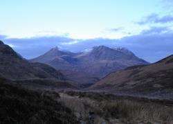
The Skye Trail
Start/finish — Rubha Hunish, Trotternish/Broadford.
Distance — 70 miles.
Terrain — Minor roads, footpaths, pathless mountain country, includes "The Bad Step".
More info — The Skye Trail by Cameron McNeish and Richard Else.
I HAVE long looked at the Trotternish ridge and thought about walking it from the north right into Skye’s main town, Portree.
That’s exactly the way this route — filmed for a BBC television series — begins, with the added incentive of starting right at the northern tip of the peninsula. It then goes on to visit the mighty Cuillin and passes "The Bad Step" en route to Camasunary before climbing Bla Bheinn and continuing through a more gentle passage to Broadford.
The unofficial route gives an excellent taste of what Skye has to offer, from the excitement and solitude of the mountains to the busy streets of Portree.
It relies on the walker having excellent navigation skills and experience in the Scottish mountains and, for those who do, this is a superb route around this wonderful island.
Highland Drovers’ Walk
Start/finish — Skye/Crieff.
Distance — 200 miles.
Terrain — Old drove road now mostly estate or forest tracks, some tarmac road (with alternative route options), high mountain alternatives, paths, pathless in parts.
More info — The Famous Highland Drove Walk by Irvine Butterfield, published by Grey Stone Books.
STARTING in Glenbrittle below the magnificent Cuillin of Skye, this long-distance route is one that was followed by the drovers of that isle only a few hundred years ago.
Surprisingly, much of the route remains off-road, though estate and forest tracks help along the way. Most of this route follows official rights of way and goes through some spectacular mountain scenery.
I know many of the areas this route passes through from hillwalking including around Killin, Bridge of Orchy, Glencoe, Spean Bridge, Glenelg and Skye, but the thought of driving cattle along this 200-mile route to market is something else.
As much of the route remains relatively wild, it’s possible to imagine the drovers of old cutting their way through the hills.
This type of route is one of my favourites because there’s a real history to the route you’re following, not simply linking up paths and tracks to get from A to B.
Being an unofficial route, there is no waymarking apart from the Scottish Rights of Way signs you may encounter along the way.
Moray Coast Trail
Start/finish — Forres/Cullen.
Distance — 50 miles.
Terrain — Beaches, coastal paths, quiet road, disused railway, tarmac cycle path.
More info — www.morayways.org.uk/moray-coast-trail.asp
THIS great walking route follows the wonderful Moray shoreline between Forres and Cullen, passing Findhorn and Spey Bay on its way.
It’s a fantastic route that can be linked with the Speyside Way and Dava Way to make a longer "Moray Way" trail.
The route is well signposted and includes sections along some of the fine golden beaches the area has to offer, as well as above magnificent cliffs and caves. There’s also the chance to spot plenty of wildlife as the way goes through towns, forests, farmland and open areas.
Towns along the route are nicely spread out, allowing you to take it easy in between and refuel at the many cafes on the way, as well as take in historic attractions from ice houses to World War II fortifications. There are a number of recognised campsites, as well as B&Bs and hotels along the route too.
This is a particularly scenic long-distance route with some rough walking but largely very accessible from the settlements along the way. A great way to discover Moray!
Great Glen Way
Start/finish — Inverness/Fort William.
Distance — 79 miles.
Terrain — Paths, canal towpath, forestry tracks, tarmac road, pavement.
More info — www.greatglenway.com; Harvey Great Glen Way map.
THE Great Glen Way links Inverness with Fort William down the length of the Great Glen fault, passing Loch Ness, Loch Oich and Loch Lochy on its way south.
This official long-distance route — one of only four in Scotland — is well waymarked and has some superb highlights. These include Thomas Telford’s Caledonian Canal between Fort William and Gairlochy — including Neptune’s Staircase — with fine views into the north face of Ben Nevis, Britain’s highest mountain; the beautiful Bridge of Oich and, of course, some spectacular views over Loch Ness and the Great Glen.
The route has received some criticism for its reliance on long stretches of forest track and minor roads in some sections, but further path stretches have been added in recent years.
This use of forest tracks does make it popular with mountain bikers, and it’s possible for fit riders to pedal the Great Glen Way in a day (as I did for Active Outdoors in August 2009).