


Taking it to extremes on trip to far north
Register for free to read more of the latest local news. It's easy and will only take a moment.

There’s something about extremes that sparks people’s imagination, and Dunnet Head is nothing if not extreme.
The headland juts out into the Pentland Firth, coming to an abrupt halt less than seven miles short of the nearest point in Orkney, and a good two-and-a-half miles further north than everyone’s favourite destination on the End to End cycle, John O’Groats.
Personally, I still think of Duncansby Head as the true finishing point to the End to End, given its extremity at the north-east corner of the country, but that’s by the by.
The map of Dunnet Head shows a road curving its way north through a land dotted with lochs to the very tip of the country. I just had to get myself there – and before I do the full End to End journey myself, which will hopefully be in a couple of years’ time.
My route for the day started at Thurso railway station, a long haul on the early train from Inverness for me – a fine rail journey in itself.
I headed up to the main road and turned right down the hill, joining Route 1 of the National Cycle Network which the route follows to begin with. Look out for the blue cycle signs which direct you right through the square then straight over at the lights to briefly join the A9 as it crosses the river in the town.
Turn left at the next traffic lights (opposite Tesco) then go right a few hundred metres up the road to climb away from the houses and up into the open countryside on a narrow road.
Taking a break part way up, I enjoyed magnificent views back over Thurso and Scrabster and out to Orkney, even making out the Old Man of Hoy in the hazy distance. I hoped it would stay clear enough to get a closer look from Dunnet Head.
Further up, take a left turn, signed for Castletown, down a magnificent twisting road that offers a direct view to the cliffs of the headland. I could see the waves battering them at their base, even on a relatively calm day like this. It makes you realise where you’re heading is effectively more in the sea than it is on land, certainly in terms of how exposed it is.
Dropping into Castletown, go straight on across the main road and follow a wonderful minor road past the Flagstone Trail – a short walk looking at the ruins of a thriving industrial past here – and beyond the pretty harbour which looks across the sandy beach of Dunnet Bay.
Turn left to follow the A836 briefly before turning right, still on Route 1, past some farm buildings and other houses. Turn left at the T-junction then, after another mile or so, take a left turn signed to Barrock to pass Loch Heilen away to your right.
Soon the route leaves the NCN, turning left where Barrock is signed a quarter of a mile away to head straight down to the main road again. Dunnet Head is signed straight on here, and you follow the wonderful road to the shore at Ham where it bends tightly around the ruins of an old watermill beside a pretty loch, unnamed on the OS map.
Stick to the road as it bends left to reach the settlement at Brough, going right where the Dunnet Head viewpoint sign shows.
By now my hopes of a clear view were well and truly blown away – it was throwing it down and I took cover in a roadside shelter at the junction to escape the rain for a few minutes, despite being soaked to the skin already. Dunnet Head was showing another of its extremes – the weather.
With only three miles to go, I ploughed on through the rain, still enjoying this stunning road with views that, on a clear day, must be truly awe-inspiring.
It passes through heather-clad bog, intersected with fine lochs, and the road itself is a pleasure to ride on. A delightful wide hairpin bend takes you up, at a fairly gentle gradient, to the high point while milestones tell you how close you are to the lighthouse.
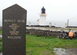
Finally I was there, as far as you can go northwards on the British mainland.
It may only be seven miles to Orkney but I certainly couldn’t see that far through the rain and cloud that had descended since I began in Thurso. A few visitors huddled in their cars and a man who had walked here hid in one of the old wartime lookouts in a presumably vain attempt to stay dry.
I turned and headed back to Brough, turning right towards Thurso to skirt around St John’s Loch and meet the main road, which I would follow back around the bay to Castletown and on to Thurso.
By the time I got there – you guessed it – the rain was off and I even spotted a patch or two of blue sky. Maybe next time I’ll have more luck with the weather because one thing’s for sure – it’s extremely likely I’ll be back at the most northerly point on the British mainland again, perhaps on my way to Duncansby Head.
For more about things to see and do at Dunnet Head, visit www.dunnethead.co.uk