


Staying out for the soggy summer. . .
Register for free to read more of the latest local news. It's easy and will only take a moment.

Perhaps it will start raining
that’s not so good for you
but biking when it’s raining
can be exciting, too.
So says a page in one of my little daughter Clara’s favourite books, Miffy’s Bicycle.
With the way this summer is shaping up, it’s a page I’ve memorised to inspire me on these wet days that seem all too common.
Sometimes you just have to ignore the weather and get out there anyway, so I decided on this excellent circuit from the centre of Inverness. It’s one I’m familiar with, having done it a number of times – in all seasons.
Part of my plan involved checking the National Cycle Network signs on the part of the route from Inverness to Craggie, near Daviot, which I do as a volunteer for the sustainable transport charity Sustrans.
That meant I was towing my trailer, all good training for some of the multi-day adventures I’ve got planned later in the year!
The route starts in the railway station. Take the exit signed to Falcon Square, then head right, in front of Pizza Express, to the pedestrian crossing.
Head up the pedestrianised Inglis Street across the road then go left onto the High Street. At the end, join the road and follow the NCN Route 1/7 sign up Crown Road, past the Eastgate Centre car park.
The cycle route is well signed as it leads you through the Crown area and then alongside the golf course beside Diriebught Road, going left onto Culcabock Road and over the roundabout onto Old Perth Road.
Beyond Raigmore Hospital, you can join the shared-use path on the left before the bingo hall, crossing at the traffic lights then continuing over the A9 past the site of the new University of the Highlands and Islands campus at Beechwood.
Go left on the path, following the cycle sign towards Culloden and Tomatin then the Route 1/7 signs up through Resaurie, from where there are usually fine views down over the Moray Firth.
The view was grey and dreich today as I rode through a drizzly mist that turned to heavier showers at times. Going straight ahead when emerging in Smithton, I continued past the shop then turned sharp right, still following the blue signs. Go left at a wall and follow the track between houses then over a burn and along to Culloden Avenue the other side of a road crossing.
There’s a great section through the woods here, and you can even see the Gruffalo – as visited on a previous Active Outdoors walk in this area (see our website for details) – as you go through the underpass and continue to emerge at Culloden House.
Go right at the gated entrance to the hotel and follow a short bumpy track to a pedestrian crossing. Cross here and turn left on the other side of the road, sticking to the new shared-use path that leads all the way to Cherry Park at Balloch.
At the corner here I met a nice couple from Cape Town in South Africa who had cycled all the way from Carlisle, through some horrendous weather. They were very enthusiastic about the cycle network... but did ask when the rain was going to stop!
I turned right here and followed the road round to the shop, where you turn right for the big climb through Balloch. It’s long and relentless but it’s a hill you just have to accept, drop it into a low gear and keep going.
On the way up I chatted to a couple of guys who were following Route 1 all the way to Newcastle, a route I haven’t done but one that I’d love to try. At around 520 miles on the cycle network, it’s a serious undertaking but great for an active holiday.
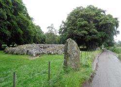
At the T-junction at the top of the hill, you can divert a few hundred metres right to visit the Culloden Battlefield Visitor Centre (which has a cafe with some impressive home baking) or continue straight on over the next two junctions to drop steeply down to cross the River Nairn. Today the normally peaceful channel was a torrent of brown water rushing down the glen. I turned right where the NCN routes split – Route 1 going straight ahead to Nairn (and eventually Aberdeen and Newcastle) and Route 7 going right past the Clava Cairns towards Tomatin, Aviemore (and ultimately Glasgow and Carlisle).
Looking back, the dramatic railway viaduct over Strathnairn was only visible through a hazy mist, but nevertheless looked as impressive as always. Route 1 actually takes you right underneath one of its 29 arches.
There’s another steep pull up to the top road on Route 7 now, and I was pleased to make it through the tough part under the railway and past the farm without resorting to my very lowest gear, even with the trailer on!
Follow the cycle sign right at the top and there’s finally a chance for a relatively flat section as you head the few miles along to Craggie, where you meet the B9154.
Turn right here, leaving the cycle network behind, then fork left at the war memorial to pass a row of houses, taking the newer of two parallel roads at the end. Keep on this road to reach an underpass which allows cyclists, walkers and horse riders to avoid crossing the busy A9 and emerge on the B851 on the other side.
Keep straight on until Inverarnie, where you turn right just after the football and shinty pitches to pass a shop then cross the River Nairn again before a steep climb which eases but continues for some way through the forest.
Eventually you reach Tomfat Woods car park and from here it really is all downhill – with spectacular views over the city of Inverness and the Kessock Bridge, out to the Black Isle and beyond. Even today, the view was striking, but on a fine day this is really something to behold.
Stick to the road until you come to a roundabout (the new Asda store should be on your left), then go straight ahead and follow the road, keeping right at a mini-roundabout, until you come to a traffic-light controlled crossroads. Turn right here then fork left on Muirfield Road, going left then left again to reach traffic lights.
Turn right here past the Crown Court Hotel (on your right) and continue straight on through the next set of lights.
Where the road rises on a sharp right turn, follow the Route 1/7 cycle signs straight ahead (the no entry signs don’t apply to bikes) and go down Stephen’s Brae to reach the pedestrianised High Street.