


Speyside walk rewards with panoramic view
Register for free to read more of the latest local news. It's easy and will only take a moment.

A 360 degree panoramic view taking in the Cairngorms and Ben Rinnes awaits those who tackle this wonderful circuit on the Glenlivet Estate.
The summit of Carn Daimh (pronounced something like “Cairn Dye”) is the highest point on the Speyside Way – albeit a spur off the main route which links Ballindalloch and Tomintoul – and for me this is the best part of that long-distance route.
The “climb” isn’t as strenuous as that word might suggest, as the car park lies at 270 metres above sea level, so the 570m summit involves only a steady climb most of the way, and through beautiful scenery.
Glenlivet is part of the Crown Estate, and there are a number of waymarked trails around the area, so navigation is fairly straightforward, though it’s still worth taking a map on this route.
The starting point at the Clash Woods car park can be found just north of the village, where a tiny blue parking sign points you down a minor road off the B9008. A notice board here shows the estate map with a number of possible walks, with further details available at the Tomintoul information centre.
I headed up the forest track for a hundred metres or so before going left on a wonderfully twisting path that leads along the edge of the woodland to reach a gate and stile at Eastertown.
Cross the two stiles marked with blue arrows and take the left of two farm tracks at a fork to head up towards the corrie ahead. It was remarkably peaceful up here and the only sounds I could hear were the woodland birds singing and the nearby burn trundling down from the hillside above.
The forecast had been for showers so I was surprised when the sun came out and I had to take my jacket off rather than put a waterproof on.
Soon the track passes Westertown farm, where it crosses a small wooden boardwalk bridge beside the ford then climbs by S-bends to a gate. There was no stile here so I hopped over the wooden fence beside the double gate to continue through a small patch of muddy woodland and down to cross another burn by a ford.
The path ahead goes through what looks like deserted farmland, with a ruin tucked away in the corner of a field at Craighead. Keeping between two fences, the route is straightforward, if a little rough and rutted, as it climbs to meet the corner of a forest plantation.
The curlews appeared to have taken over the farm, as they noisily swooped and screeched to protect their nest sites in the open fields. I stopped to watch, as well as to take in the marvellous view behind to Ben Rinnes, which still had patchy snow dotted across its high slopes.
Go through the gate into the forestry and follow the track, muddy again here, to a junction marked by a wooden signpost. This is where the route joins the Speyside Way spur, as you turn right to follow the sign towards Ballindalloch, up an initially steep track.
It eases after a right-hand bend, where I decided to take a detour to the top of Cairn Ellick, following a grassy track left. Just 50 yards on, this provides a great view to the top of Carn Daimh over to the right, and the cairn marking this lower top is just a little further on, through an opening in the trees.
Returning to the main track, I went left to continue downhill to the edge of the forest.
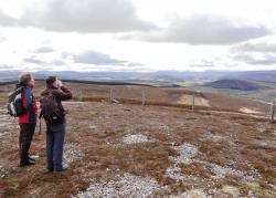
Over a stile, the route now joins a clear hill track as it climbs the final rise to the summit of Carn Daimh. I reached the top just as a couple came up from the far side, and we all admired the spectacular panoramic view.
My eyes were drawn to the Cairngorms, where cloud gathered and you could see rain and snow sweeping across the plateau as we stood in the sunshine. In the opposite direction, Ben Rinnes dominated but it’s even possible to see Morven in the far north from here.
After having a quick bite to eat, I started to head down, taking the path to the right of the fence along the outside of the forest plantation. It was pretty boggy down here and patchy snow made it slippery too, not to mention a number of fallen trees across what remains of the path meaning I had to divert around them on several occasions.
I soon passed the short-cut path that goes back to Westertown (signed to Tomnavoulin) and continued to a fence where the route turns right. Leave the Speyside Way here and continue up the incline through the heather on this side of the fence. Near the top the path becomes clearer and it goes left beside a lone tree before skirting round to the right and following another fence downhill.
Cross it at a stile and follow the well-eroded way across the field towards the gap in the trees below. There are many possible paths here but the route follows the outside of the plantation around the first corner then follows the remains of a track to enter the forest by a stile ahead.
Keep to this track all the way now as it descends, quite steeply in places, along the edge of Clash Woods, with some fantastic views across the open countryside to enjoy before going past the path near the car park.