


Small but perfectly formed
Register for free to read more of the latest local news. It's easy and will only take a moment.

THERE’S a hill near Ullapool that’s masquerading as a Munro. I know because I’ve climbed it and had an easier time on actual Munros. The hill in question, Beinn Ghobhlach, is the highest point on the peninsula that divides Loch Broom and Little Loch Broom.
View it travelling south on the lovely scenic road that winds round Gruinard Bay heading for Dundonnell and you’ll understand why I’ve described it as a pretend Munro.
It looks a lot bigger than its 636 metres suggest, and is surrounded by rough moorland. A steep, craggy face characterises the north side and there are more crags on the south-west face.
It’s these features and its lofty, isolated position that make Beinn Ghobhlach so imposing – and attractive. But it’s not a hill to be trifled with.
To climb it involves a drive – or bike ride if you’re so inclined – along the single-track road that joins the A832 near the Corrie Hallie car park, used as the main access point for An Teallach. The hamlet of Badrallach is reached after what seems like a long journey round the head of Little Loch Broom. There’s room to park at the end of the road, where there’s a turning circle.
I set off at a sprightly pace under a dull but clear sky along the coastal path that ends at Scoraig. The surface is good, with some great views down the loch and across to Sail Mhor on the other side. It’s a cracking walk in itself.
Beinn Ghobhlach is hidden above, guarded by a steep foreground that must be breached before higher and somewhat flatter moorland can be gained. I continued walking for about five kilometres to a gate on the edge of a small woodland with the houses of Ruigh’riabhach beyond. A faint path to my right began to traverse rough ground a few metres away from a fence. I carried on to a significant rise and plodded slowly up to the lip and my first, somewhat truncated view of Beinn Ghobhlach, its two ridges projecting outwards, split by the scoop of Coire Dearg.
I’d come prepared for snow, carrying crampons and an ice axe, but surprisingly there was none, and less than expected on bigger surrounding hills too. The walk over the moorland to the corrie is pathless but not difficult and I soon found myself at its base. A grassy and heathery ascent followed and I kept towards the left-hand side of the corrie, making for Beinn Ghobhlach’s north top.
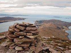
The vegetation gives way to a rocky ridge made up of sandstone plates. Once on it, it’s just a short step to the cairn on the north top and a dramatic view over the peninsula to the sea. The Stornoway ferry was edging out of Loch Broom from Ullapool as I stood gazing at the view – a mere child’s toy from this elevated position.
I turned and carried on round the ridge to climb the very even, stony slope to Beinn Ghobhlach’s summit. There are more spectacular views from here to Sail Mor, An Teallach and the Fannichs.
A pair of lochs – Loch na h-Uidhe and Loch na Coireig – sit in a bowl beneath the summit and my next objective was the strip of boggy land that divides them. The route down is steep and needed careful foot placements, especially where the ground was still frozen near the summit. However, there is a path most of the way and I zigzagged carefully along.
As I descended a herd of around 40 deer darted round the hillside below me then stopped, as they do, to gaze back at this interloper on their territory.
The area around the lochs is picturesque and although I squelched across the boggy spit between them, I thoroughly enjoyed this wild setting. Staying fairly close to the shore of Loch na h-Uidhe I passed below the little top with a spot height of 338 metres on the map and over a slight rise. The way down from here looks a little daunting with convex ground giving no view of what’s ahead. But it’s actually fine and it soon becomes obvious that you are in a broad gully that narrows towards its base.
Sticking to the right flank of the gully I lost height until the Scoraig path came into view. A burn, largely lost in the undergrowth, can be heard gurgling at the base of the gully.
Once on the Scoraig path, Badrallach is just a couple of kilometres of easy walking away.