


Series of bridges lead to an impressive waterfall
Register for free to read more of the latest local news. It's easy and will only take a moment.

WALKING ROUTE
Big Burn at Golspie
Distance – 2¾ miles
Terrain – Riverside paths and steps
Maps – OS Explorer 441
Start/finish – Big Burn car park, off A9 at north end of Golspie
Explore gentle woodland paths to discover some remarkable water features
Hidden waterfalls and a series of intricate woodland paths make this a fascinating circuit of the Big Burn at Golspie.
There are a number of access points to the walk, but the easiest is off the A9 at the north end of the village, where there’s a car park behind the stonemason’s next to the Golspie Inn.
The short track is a narrow squeeze for the car but there’s a small parking area and an information board with a basic map of the paths at the end, beside the old Thomas Telford bridge which used to carry the A9 into the village.
An old rusting sign points you towards the waterfall along a well-made path, which soon reaches an arched wooden bridge across the burn. The bridge is dedicated to Colin Ploughman, who came to the area during World War II to fell timber for the war effort and who more recently voluntarily cleared trees and helped to keep the Big Burn walk accessible.
Continue under the massive railway bridge alongside the burn then cut right through a picnic area and cross a number of tributaries as the path meanders further inland. Go left where a tiny coloured signpost at ground level hides beside a bench, and keep to the path nearest the burn.
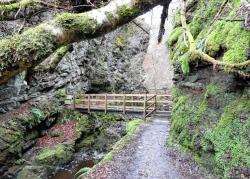
Soon you’ll reach one of the highlights of this wonderful little route, a series of footbridges that take you to and fro across the Golspie Burn, to give it its real name, through a narrow, rocky gorge.
You can smell the damp, clean air as trees overhang the path and mosses and lichen abound on the rocks and branches. The first few bridges take you over the burn then back again, with a pretty waterfall fanning down from the far side, spraying you a little as you get nearer.
The path then cuts left, crossing the burn again in the tight gap, continuing upstream for a short distance then crossing yet again. Go left to cross back almost immediately, then, at the far side of the bridge, it’s worth taking the detour to the right along a narrow path and boardwalk that leads to the bottom of the main waterfall on the burn.
As you reach the end of the overhanging boardwalk, you can hear the pummelling water getting louder and, turning the corner, see it funnel through a narrow crevasse and drop to the pool beside you.
Returning to the bridge, go right and climb up the steps that take you to the top of the waterfall, where you can look over the edge if you dare! Otherwise, take a break on the bench just over the bridge, then turn left when you’re ready to carry on.
The path follows the burn and at one point almost merges with the upper path – which we’ll follow on the way back – but for now stay left on the path closest to the burn. Just as you can see a house ahead, another bridge leads you left across the burn once more and then a path climbs up from a simple bench to meet the minor road.
Turn right onto the road and follow it round a sharp left-hand bend down to the bridge at the bottom. You may see ahead the link route on the Highland Wildcat mountain bike trails that connect the Backies road with the main off-road routes.
Cross the bridge and turn right through a little gate, staying immediately left of the track that leads to the house. There are fantastic views from this little path, both ahead through the trees and over the burn to the Duke of Sutherland monument on top of Ben Bhraggie.
You’ll skirt close to the path you met earlier before passing the Backies road car park – another possible starting point for this walk. Down to your right beyond here a hollow holds a forest of trees lathered in lichen and the view overlooks the Moray Firth in the distance.
Reaching a pond, I decided to do a circuit of it before heading back to the car. The water was mirror still, and on this cold day it even had a very thin layer of ice clinging to the edge, so the surrounding trees were perfectly reflected, even if the ducks were a little confused coming in to land! From the far side I could see up to Ben Bhraggie again through the branches of creeping trees.
After completing the circuit of the pond, I headed down the steps which lead to the junction with the dinky signpost then went back under the railway and over Colin’s Bridge to the car park.
This great little circuit of the burn feels like a million miles from the busy A9, and its hidden features make it a superb outing at any time.