


Rediscovering an old favourite
Register for free to read more of the latest local news. It's easy and will only take a moment.

It had been a long time since I’d done the ride to Cromarty from my home in Inverness and I thought it would have to wait until the spring before I got another chance.
The route, which follows the National Cycle Network Route 1 – with a couple of interesting diversions on the way back this time – is one I love to do.
With the prevailing wind behind me I can usually get there in a couple of hours, though the return can take a bit longer if the wind picks up!
I managed to find a free Sunday in the diary when the weather looked okay, and headed out from home wrapped up against the chilly morning. It turned out to be a wonderfully sunny day, better than expected, and I thoroughly enjoyed the long cycle, getting back just before dark on one of these short winter days.
The route is described here from the High Street in Inverness and initially heads down Bridge Street to the River Ness. Turn right onto Bank Street and follow the cycle route signs around the one-way system to continue following the river downstream, under the Friar’s Bridge.
At a T-junction, go left then right onto Portland Place, turning left onto Shore Street at the end of the road (closed to cars) opposite Highland Bikes. Continue until just before you go under the Kessock Bridge, turning right before the Inverness Courier office then going left onto a cycle track signed for the Kessock Bridge on NCN1.
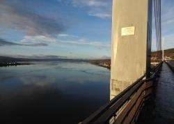
Crossing the bridge I got an incredible view over the Beauly Firth and Inverness to my left, with the Black Isle stretched out along the edge of the Moray Firth across the other side of the main road. It was shaping up to be a stunning day.
The cycle track continues alongside the A9 to the North Kessock turn-off, where it crosses the slip road and goes under the dual carriageway via a narrow underpass. Keep right at a jumble of cycle signs and follow the cycle path now on the opposite side of the road. It soon diverts right at a lay-by to meet a minor road, which you turn left onto.
Turn right then left at a junction, passing Munlochy Animal Aid on a quiet road. There were patches of ice on the untreated surface here, so I had to take care.
Take the next road right immediately after a house, following NCN1 signs to Munlochy on a superb stretch of road that passes the new Black Isle Brewery. In the village, go left and follow the main road up to a staggered crossroads, going diagonally over on the route to Killen. It’s a steady climb here until you go right (look out for the small blue cycle sign) a mile or so before the TV mast at Mount Eagle.
Go straight for a few miles to a T-junction, then turn right downhill on the B9160. Where this meets the A832, go right (ignoring the sign left for Cromarty) then get in a low gear for an extremely sharp left turn signed to Eathie as you drop down to the Fairy Glen.
As I climbed up this wonderful stretch of road, a lady caught up with me and we ended up chatting all the way to Cromarty, enthusing about the views out over the Moray Firth which are spectacular in either direction along here.
Finally reaching the A832 just above Cromarty, she headed back to Rosemarkie while I continued into the village for a break and a bite to eat. I always enjoy getting to the green beside the Cromarty Ferry slip and looking across to Nigg and out through the sutors to the firth.
I normally head back along the north edge of the Black Isle but decided this time to retrace my route along the glorious Eathie road, dropping down into Rosemarkie and visiting Chanonry Point to see if I could spot any dolphins.
In Rosemarkie, go left immediately after the Plough Inn and follow the road to a T-junction, where a left turn will take you through the centre of the golf course to the lighthouse. There were no dolphins around so I soon headed back up the road, taking the first left through the caravan site into Fortrose.
The stretch of main road between here and Avoch is no fun on a bicycle, so I opted for the old railway path which runs above. It’s a well-known local route but one that could be better signed for visitors.
The way to get there from the end of the road is to go right, then turn left up Tavern Lane. At the steps ahead, you can cycle right up a narrow sloped path, then turn left and follow the road around. Go left then right onto Station Crescent and follow a narrow path between a hedge and a fence. Once you reach the first gate, there’s a wooden sign confirming you’re on the way to Avoch!
The harbour village looked stunning from up here with calm seas and winter sunlight caressing the seaside houses. The path emerges beside a church, in a car park. Keep ahead then go left down the steep hill to the village, turning left then immediately right before the shop. If you just stay on this residential road as it twists along you’ll cross an old bridge then pass along the sea wall in front of a row of houses.
At the end of the houses, the road goes right up the hill and continues until it meets the main road further west. Turn left onto the A832 for a mile-and-a-half to the staggered junction at Munlochy, where a left turn drops you down into the village and back to Inverness for the last 10 miles of this fantastic journey across the Black Isle.