


Rail and road provides fine traffic-free trail
Register for free to read more of the latest local news. It's easy and will only take a moment.

Mixing easy off-road cycling with a little touch of simple singletrack, this circuit is great fun from start to finish.
Taken at a gentle pace, it could make a nice family ride – though one or two bumpy and narrow sections might put you off taking very young children.
I headed to Grantown-on-Spey by myself one morning and enjoyed a frosty but glorious time in the saddle.
The route basically starts at The Square but I parked at the Burnfield car park, where there are public toilets, opposite the museum. Go back to the main road and turn left, taking a right turn immediately after the Co-operative store onto Seafield Avenue.
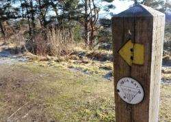
After the caravan park, head under the old railway bridge then turn right at the green signpost marked for Forres by the Dava Way. A short ramp with steps leads up to the disused railway line and the start of the Dava Way, which goes 24 miles north to Forres mostly on the line of the old Highland railway route.
This first section of the way has a good surface and I enjoyed having the path all to myself below a cloudless blue sky. The way goes through a rocky cutting before becoming grassier through some farmland and narrowing in places, then crossing the A939 on a fine stone bridge.
In the past I’ve cycled the Dava Way fully laden with panniers, which wasn’t the best idea, but without bags the riding was easy and my time on the rail route seemed far too short – but today wasn’t a day to go all the way to Forres. I followed a Dava Way marker post left onto a path which made for an excellent bit of singletrack riding which bumped up and down until crossing a short boardwalk then arriving at an estate road.
The Dava Way is signed left with an arrow but my route went right, following the road with a view to the Cairngorms in the distance to my right.
Ignore a track off to the right where the road becomes tarmac, then keep straight on where another track leads left at a large tree to some farm buildings and houses. After passing the gate to the private Castle Grant, turn left back on yourself at a track junction at the bottom of a slope.
The track now bends sharp right (ignoring one straight ahead on the corner) then twists and turns downhill through some nice woodland until crossing a bridge over a burn and climbing slightly on a right-hand bend.
Keep to the obvious track now and continue as it emerges from the woods at a house until you reach the public road ahead.
Cross here to follow the sign to Cromdale on a minor road and look out shortly after the large sign warning about a weak bridge three-quarters of a mile ahead for a track on the right marked Netherport. Go down this track and keep left where it forks just before the house then go right to cross a wide bridge over a burn, joining the Speyside Way.
To my left here the Cromdale Hills looked magnificent with pockets of snow no doubt clinging, frozen, to the slopes here and there. These would have been the perfect conditions to climb these often boggy hills while their lower slopes would be crisp and crunchy with ice.
A short way ahead, the route goes right through a gate into the well-marked Anagach Woods – a community woodland with plenty of excellent tracks and paths for people of all abilities. After ignoring a path off to the left, I got so carried away with the excellent cycling that I blasted through the next junction without a thought for whether I’d gone the right way or not.
When I got to the car park at the end of the track, I realised I hadn’t... But it didn’t matter, it was fun just to ride back to the junction and take the right option this time!
I should have originally kept left beside the bench to stay on the red route and I found the Speyside Way markers were quite clear beyond that junction, sticking to the main track through the woods.
At one point the thistle symbol that designates this long-distance route points left on a slightly muddier track that drops steeply. This was another fun stretch to cycle with a couple of burns to cross before reaching a path across the edge of a field before re-entering the woods on a decent track.
When you go through a vehicle gate leading to a turning area, follow the road right to a parking area with information boards and turn right again onto Forest Road, back in Grantown now.
The way back to The Square goes straight on at the give-way junction but I turned right to follow a quieter road back to the museum and Burnfield car park, taking the second left to reach it.