


Peaceful trail that’s perfect for exploring
Register for free to read more of the latest local news. It's easy and will only take a moment.

The Badenoch Way is a great little route that passes through some wonderful stretches of native woodland, offers fine views to the mountains and rivers and uses memorable little paths.
One problem is, though, that the linear trail starts and finishes on the outskirts of two towns with no obvious options to return to the start. You could take two cars and leave one at either end; you could check bus timetables or go a few extra miles and use the train – extending the walk from Aviemore to Kingussie.
However, what I did was to leave a bike at the RSPB car park at Ruthven – a short distance beyond the ruined barracks from Kingussie on the B970 – and take the car to the official start at Dalraddy Caravan Park south of Aviemore. I could then follow the quiet roads back on the bike after completing the trail and, with a south-westerly wind blowing, it would be an easy cycle.
The waymarked route is on the edge of the Cairngorms National Park and passes through Insh Marshes Nature Reserve, so it’s great for spotting wildlife too.
I’d recently found out that my team had been accepted for this year’s Highland Cross, so I decided to run this route to get my training off to a good start – but the 11-mile way would also make a great day’s walk, with plenty of picnic spots along the paths where you could stop and enjoy the surroundings.
The wind made it a bit chilly for stopping as I set off from the caravan park – where there’s a car park and a faded information board about the Badenoch Way just on the left down the track.
At the start, go through the gap in the fence at the far side of the car park but don’t follow the “Footpath to Speybank”; instead continue ahead to pass under the railway and through a gate to emerge in the corner of a large field.
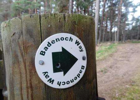
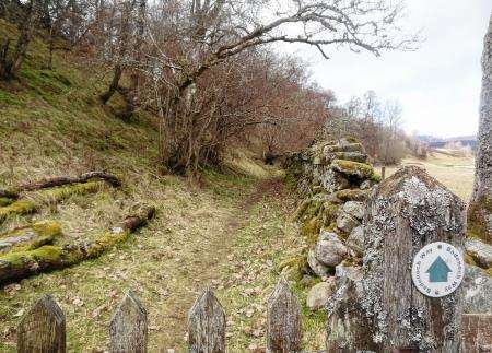
The route is reasonably well signposted throughout but you do have to keep your eyes open for the markers in places, especially as some of the arrows are faded or missing.
At first it crosses the moor to hit the edge of the forest nearest the River Spey, going right though a gate and following some intricate paths between the pine trees back towards the railway.
You head along a track beside a few houses then, just before the track crosses the railway line, cut left through a gate to follow the fantastic Speybank Walk path that teeters high above the river, with the water of the Feshie merging with the Spey below to your left.
I was soon at Kincraig, turning left where the path meets the road and following it over the bridge (take care as there’s no footway here) and round the corner.
The Badenoch Way is signed to the right behind the historic Insh Church, a detour worth taking as a nice path briefly hugs the shore of the stunning Loch Insh under the cover of the trees before passing the cemetery and returning to the road. A pavement then a footpath run parallel to the road all the way to the Loch Insh Watersports Centre, where you cut through the car park to find a signed path that leads nicely to the B970. Follow the road a short distance to the right then cut into the forest at a opening.
This section is lovely as it winds down to the loch again – with views across to the Monadhliath hills – eventually cutting back up to the road, where it crosses to meet a footpath on the opposite side. I had to duck and dive between the fast-growing young fir trees as I tried to keep running along here but the slightly overgrown path is still a nicer option than following the road, quiet as it is.
On reaching a forestry track, go left – through a green metal gate – and up the hill, looking out for a Badenoch Way marker that leads off to the right on a left-hand bend. A boggy path follows a line of pylons now and I confess I was walking most of this stretch, at least until it met the forestry track further ahead that makes up part of the Inshriach Forest trails to Farrleiter Crag. Go right onto this and follow it left before striking off to the right part-way up the hill.
I was relieved to find a long downhill to stretch the legs now and a bit of spring sunshine to add to the occasion. After passing through a cleared area of forest, turn right onto a vehicle track then go right again down to the road.
Another path strikes off left immediately before the road, signed to Drumguish on a right of way. It’s a fine stretch as it passes behind the village of Insh on the old road, continuing through the quiet hamlets of Inveruglass and the delightful Drumguish to reach the Glen Tromie track.
An enticing sign points left up the glen to “Atholl via the Gaick and Minigaig passes” – the former of which I am familiar with from previous mountain biking outings. Perhaps this summer I’ll get chance to try out the latter option too.
For the Badenoch Way, a right turn to Tromie Bridge is in order. The water was pummelling under this beautiful stone bridge at some rate on my visit. It’s not very clear from the markers but the route turns right on the far side of the bridge, entering the Insh Marshes Nature Reserve, and following a path through the RSPB land.
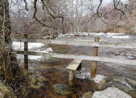
There’s a great view of the bridge from here and further on I thought I’d have to find a detour – when I came across a stile heading over a fence and straight into the river. Thankfully it turned out not to be part of the Badenoch Way but I’m not entirely sure what its purpose was! Perhaps stepping stones lead across to the little island when the water is lower – much lower.
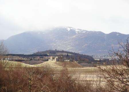
Just before the end of the way, it’s worth the short detour to a viewpoint above Invertromie, from where you can see over Strathspey to the Ruthven Barracks and the mountains beyond.
Following the trail back to the car park, all that was left was the 9.5-mile ride back to Dalraddy – via the B970, Kincraig and B9152 – which, with the wind behind, took me a speedy 35 minutes. It was a nice end to a morning exploring this lovely trail through the Badenoch countryside.