


One track mind on North Highland cycle route
Register for free to read more of the latest local news. It's easy and will only take a moment.

Stepping off the train at the remote Altnabreac station in Caithness, I didn’t know what to expect from a ride that – on the map at least – looked like the perfect circular outing.
There are no roads around here, only estate tracks mostly used for forestry and fishing as well as some farming. On the OS map, the little pink dot representing stations looked lost in a mass of forests, lochs and little else.
So I was pleased as I stepped off the train to see a map panel of the route I had planned, a welcoming sign in a place completely new to me.
The rain was on, so I tucked myself and my bike into the wooden shelter on the platform and donned my waterproofs as the train chugged off into the distance and out of sight. I had about three hours before it would return to take me home, which left plenty of time to complete the route and even explore a little further.
Heading out of the station and into the rain, I turned left at the T-junction, following the red circular route from the map panel (though the red arrows have mostly faded to white) as it crosses a low gate then parallels the railway line east. Immediately I was struck by how smooth and free-flowing the track was. I could take it easy and just enjoy the route if it stayed like this all the way around. The track had a golden, sandy surface but was solid below, giving good traction, and it was fairly easy to avoid the worst of the bumps and potholes.
A right-hand bend soon turns you away from the railway route and you get a fine view across Loch Caise, the first of many lochs on this outing. If you’ve got time, there’s also a walk around the loch here, but you’d need good waterproof footwear judging by the state of the path!
The track skirts the shore through an S-bend before going deeper into the forest past Garbh Loch then out to an opening which overlooks Loch Gaineimh. The surroundings were stunning, especially as the sun had now made an appearance and forced me to put the waterproofs away.
After the next stretch of forestry, you come to a gate and a junction. Over the low gate, turn right and go over another gate across an inviting causeway and bridge. You are crossing the Sleach Water (on your right) as it enters Loch More (to the left).
The sun was now shimmering off the water and with the wind behind me I was able to follow the long track that runs along the loch’s length and into a lonely “strath” with abandoned houses dotted here and there.
The River Thurso flows back to Loch More as you follow it upstream (though hardly uphill) towards Dalnawillan Lodge. Just before the lodge there’s a farmhouse with plenty of dogs... they went berserk as I pedalled past but thankfully they were behind cages in their kennels.
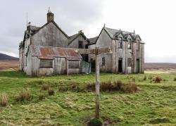
The lodge itself lies a few yards further on and is in a state of sorry ruin. A signpost outside points right, back to Altnabreac four miles hence but, as I had a little time on my hands, I decided to explore the route towards Braemore straight on.
The recognisable triangular shape of Morven dominated the view ahead, topped off with a smattering of cloud now and again.
I reached the abandoned farm at Dalganachan, where a fine stone bridge crosses the Rumsdale Water, but turned back at a gate about a mile before The Glutt as I was getting worried about the time.
This route ultimately leads through to the public road at Braemore which heads into Dunbeath on the east coast, a fine off-road outing. I’d be interested to hear if anybody knows what the track is like between The Glutt and Braemore for cycling.
Turning back to Dalnawillan Lodge, I had to battle against the wind with tired legs now. Sparking the dogs off again, I turned left to continue the circular route and complete the final four miles back to Altnabreac.
It felt to me like this was the hilliest bit of the route but in truth there were no significant hills here either, just my tired legs and a headwind to contend with!
Inspired by the beautiful Loch a’ Mhuilinn, I kept going back into the final stretch of forestry and past the hidden gem of a building beside Loch Dubh. Now it was a short stretch of downhill before keeping right to cross the Sleach Water again and keeping right at another wooden signpost – which hints at another possible through route in the area – back to the station.
The other through route links Loch More with Forsinain in Strath Halladale, and is also shown on the map on the station platform.
This circular route gives a great taste of adventurous off-road riding, and may even have you planning your return.
See more pictures on our Facebook page here