


Mysteries on the Tomatin circuit
Register for free to read more of the latest local news. It's easy and will only take a moment.

WALKING ROUTE
TOMATIN-SLOCHD CIRCUIT
Distance – 7 miles
Map – OS Explorer 417
Start/finish – Tomatin
Discovering new routes with new mysteries on a fine walk in Strathdearn
THIS captivating circuit follows two quiet routes which would once have been busier with traffic of very different kinds.
It follows part of the old A9 over an interesting bridge before returning on an old military road which was, at one time, capable of carrying wheeled carriages all the way from Inverness to Edinburgh.
Today a large section of the Wade road from Slochd summit to Raigbeg near Tomatin is lost, though an alternative route still links the two places along a right of way.
We followed the clear track without realising we had gone past the point where the Wade route — at least as marked on the OS map — diverts right. There was no evidence of a junction on the ground and the right of way clearly follows a good vehicle track all the way.
A return trip to do some exploring may be in order, but the route still offered a fantastic outing through Strathdearn.
We started in the village of Tomatin, parking in a layby at the entrance to the village before the church — a small green hut above the road on the left.
The walk follows the quiet road past the village shop and due south to curve left over the Findhorn Bridge. As the engraving on the bridge explains, this one was built in 1926 to replace Thomas Telford’s 1833 example.
Looking down the River Findhorn from here, you can see the modern A9 as well as the railway passing high above Strathdearn, which we would get a much closer look at later.
Continuing up the road, which has no pavement but does not really need it due to the low levels of traffic, our interest was maintained by fascinating buildings, gardens and views of the lower-lying Monadhliath hills.
Approaching Slochd summit, the road crosses the railway then, just before it meets the A9, you fork right onto a cycle track. We noticed across the road an old sign for the summit, broken and rusty, that motorists zoom past regularly without ever noticing. It is a remaining relic of the old A9, which once cut its way through this narrow slit in the rock along with the railway; now the new A9, the cycle route and the railway share a slightly larger cutting through the Slochd.
Just after the summit of the railway, marked with its own sign, turn left and very carefully cross the A9 to meet a track opposite. A Scottish Rights of Way Society sign marks the route back to Tomatin up the hillside, rather more wild than the tarmac route so far.
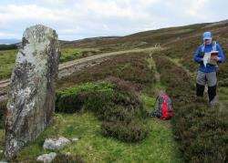
At the top of a short stretch of track, we were fascinated by a standing stone (unmarked on the OS map) which appears to mark the Slochd summit on the Wade road. Is this an original feature of the 1730 road, I wonder?
You stay left here, following the obvious track straight ahead where other tracks divert left and right further on. This is prime grouse shooting moor, but the route follows a right of way the whole way to Raigbeg.
After a gate, the original route of the Wade road apparently forks right, though we plodded on following the clear track with no knowledge we had headed a different way.
Beyond another gate the track became grassy and we reached a track junction, the first place we realised we hadn’t stuck to the line of the military road.
Go right here and enjoy wonderful views down the Findhorn over Raigbeg and Corrybrough as you wind down through lovely forestry.
At a large rock — possibly another Wade road marker — we noticed the obvious line of the military road heading back south-east. I went to explore and discovered that, after a short stretch of useful vehicle track, the line fades to nothing after a gate. I wonder what has happened to this original road, which nearly 300 years ago was capable of carrying the main vehicle traffic of its day.
We continued down the clear track to the houses at Raigbeg, meeting the tarmac road after skirting right then left round the side of them to see a rights of way sign pointing back to Slochd. The view of the viaducts across Strathdearn from here is magnificent, with the concrete turrets of the road bridge holding huge steel girders which support the modern A9.
Beyond it, the impressive railway viaduct rises into the sky from the banks of the Findhorn, an unbelievably dizzying sight from down here.
Turn right onto the road, then go left to cross a wooden bridge over the river towards Tomatin. This road loops left under the road and rail bridges before returning to the village just opposite the shop. Go right to return to the parking bay.