


Monument stays tantalisingly out of reach on extensive trail network
Register for free to read more of the latest local news. It's easy and will only take a moment.

BIKING ROUTE
HIGHLAND WILDCAT TRAILS
Distance — 9 miles
Maps — Highland Wildcat leaflet, available locally, or see www.highlandwildcat.com; OS Explorer 441
Start/finish — Backies Road car park, Golspie
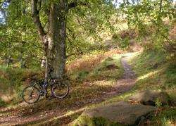
Taking the tame option at the Highland Wildcat Trails in Golspie
A FEW months ago I wrote about a walk up Ben Bhraggie above Golspie and promised to return to try out the area’s mountain bike trails.
So I headed back up the A9 to see what the Highland Wildcat Trails had in store.
Not wanting to do anything too technical on two wheels, I headed for the Backies Road car park, which is a great starting point for family trails and the less technical blue graded mountain bike routes.
The route I did uses mostly the blue route, with a little bit of the slightly tougher red grade and a nice easy stretch of (downhill) minor road, but there is an almost endless range of routes you can try to suit your skill and experience level.
To find the car park, go all the way through Golspie and out of the 30mph-limit, then turn left at a small sign to Backies, passing under a narrow rail bridge on the single-track road. The parking area isn’t signed but you just turn right along a short track immediately before a blue pedestrian sign for the Big Burn Walk. There’s normally a small charge for using the trails — just to help with their upkeep — but the machine at the car park was out of order on the day I was here.
Last time I was up this way I got caught in a terrible rain shower near the top of Ben Bhraggie, so I was hoping to make it back up to the monument to make the most of a wonderfully clear day.
On the bike now, I headed back to the minor road and turned right onto it. At the far side of the parking area for the Big Burn Walk a single-track trail is signposted parallel with the road.
It soon turns away from the tarmac and into the woods, crossing a burn via a nice stone feature. The route is signed as a blue route and sometimes just as "link route" or "shared trail". Keep following it to a series of hairpin turns which lead down nicely to a stone bridge over the Golspie Burn, part of another minor road.
Just the other side of the burn, turn right back onto the off-road trail, which now climbs steadily back up the other side, skirting the edge of a delightful little tributary tumbling its way down to meet the main burn.
As the trail starts to zigzag ahead, I got my first glimpse of a spectacular view — I could see over the firth to Portmahomack and the Tarbet Ness lighthouse through the hazy sunshine.
After a prickly stretch through some fairly dense gorse, I came out on a track, keeping right to join it before turning left through a gap in the wall.
The wall marks an old deer enclosure, hence the name of this section "Deerhunter" on the trails map. Keep on the single-track as opposed to the soggy vehicle track here and eventually come out at another track after a straightforward bit of trail.
Follow the track for just a few yards before the start of the single-track proper, which goes right at a marker post. The blue route is called "Powerline" on the post, though there’s no mention of this name on the trail map.
Nevertheless, it’s a great climb of just under a mile on pure single-track, with a few easy obstacles that are all avoidable. Cleared sections of forest along the way open up the views south down the coast and out across the Moray Firth once more. Even the electricity pylons you pass under don’t seem to spoil this expanse of Highland beauty!
Where you hit the quarry road, turn right to keep on the easy stuff — the black route ahead is for expert mountain bikers and is way beyond my own ability.
Soon I reached a crossroads. I thought I’d aim for the monument by the "back road", as I know the forest track leads all the way round the back of Ben Bhraggie to the top. However, my plan was scuppered by a high locked gate a short way up, so I decided to continue on the blue circuit for now.
made my way back to the crossroads and headed straight down (right if you ignore my needless detour!). Passing the gap in the wall again, I continued straight on instead of following the trail back left. This takes you round a metal gate and out to the minor road, which you join by going straight on. It leads you easily downhill to the village, passing under the railway before meeting housing.
Take the second right onto Ross Street and continue along it to the junction opposite the swimming pool, where a right turn will lead you along to the fountain.
When you reach the fountain, go right (there’s a sign to "Ben Bhraggie walk" up this road) and then turn right into a newer trails car park before the farm. A relatively new two-way trail takes you nicely up on single-track with avoidable obstacles — this time much trickier as they are red graded — to meet the cairn climb, so-called because of the nearby burial chambers.
To see one, walk to the gate at the edge of the farm field and look to your right where there is a curious stone circle surrounding an ancient tree.
Continue up the single-track climb to meet a forest track and turn right along "Coconut Alley" to meet part of the blue route. I decided to have another go on the "Powerline" climb as it was such fun the first time, and it was even better now I knew what to expect around each corner.
This time I followed the blue route back round and, from the gap in the wall, kept to my outward route on the great single-track back to the Backies road.
These trails offer a fantastic outing for many different levels of user. My only criticism would be that only the black grade trails take you to the monument — and back down. As such a dominant feature on the skyline, it would be great if the less technical among us had options that took us right to the monument.
For the time being, I’ll have to stick to the lower level stuff — but there’s plenty more fun to be had on the blue and red trails yet.