


Map reading skills to keep you safe in the hills
Register for free to read more of the latest local news. It's easy and will only take a moment.

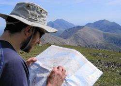
John reading the map on Glamaig, Skye.
Maps are like art to me. I can stare at one for hours, obsessing over its contours, its snaking roads and intriguing paths.
Some people find this obsession odd, but I know there are increasing numbers of map addicts, even in these days of satellite navigation. Perhaps it’s the technology that is making us traditionalists more vociferous.
Global Positioning Satellite systems have their place – I confess to actually using one on my bike – and I also have mapping software on my computer that shows the whole of Great Britain at Ordnance Survey 1:50,000 scale.
But there’s nothing quite like the crisp, folded sheet of a paper map. I also have a vast collection of these, including many of the OS Landranger and Explorer series, Harvey Superwalker maps, Sustrans cycle maps... the list goes on.
I always recommend taking a good map on the walks and cycle routes featured in Active Outdoors, but this becomes absolutely essential if you are venturing into the Highland mountains.
Just last month I was out in the Cairngorms with Active Outdoors Munro bagger Peter Evans and we spent much of the day high up in the cloud (you can read all about our adventure in the Inverness Courier next Friday). That meant we had to trust our map – and our ability to read it well – to get us home safely.
It’s easy to make a mistake in the hills, even in good weather. I should know; I’ve made a few!
On a trip to Skye a few years back, for example, some dodgy navigation led us far too near to the base of the dramatic Pinnacle Ridge, scrambling over some steep and rocky terrain when we should have made a relatively simple ascent up to the ridge between Sgurr nan Gillean and Sgurr Beag.
The mistake was easy to rectify in the clear weather, but on another day it could have been quite dangerous.
Moments like that always make me reassess, and I often practise my navigation skills at home these days, so they are quite natural when out and about in the harsher elements in the mountains.
So I thought I would share some of the basic map skills I regularly use while out on my many adventures in the Highlands and elsewhere.
Understanding the map
Knowing what the two-dimensional map is saying is the crux of map reading and therefore navigation. I called maps “art” earlier, because they are a representation of the landscape, not a straight copy of it.
Different maps use slightly different symbols to represent things in the real world, from crags and boulders to buildings and roads.
First of all, check the scale of the map you are using. Remember, the same distance on a 1:50,000 is twice as far in the real world as it is on a 1:25,000 map. It’s easy if you check the National Grid, as each square represents one square kilometre.
Next comes the terrain. The main point here is contour lines, which represent the height of the land. Some maps also use shading or colouring to mark different heights. On an OS map, contours are 10 metres apart, which means that between every contour there is a height difference of 10 vertical metres.
Being able to picture the shape of the land from contour lines is the most difficult, and most important, part of reading the map in the mountains. It means you can easily recognise ridges, corries and the gradient of climbs or descents, and plan a safe route accordingly.
Grid references
Being able to pinpoint where you are on a map is all very well, but telling somebody else (like the mountain rescue service in an emergency) is less easy. Using the National Grid, however, means you can identify a grid reference of the point.
Even if you navigate with a GPS unit, you should be able to take a grid reference in this way in case your batteries run out or the weather stops it from working.
NH 546345
This grid reference represents a 100m square and is made up of a few different parts:
The NH is the letters in the top right of the map sheet, and represents a 100km square area of the United Kingdom.
54 is the Easting, and is read from the closest vertical line to the left of the point. The 6 is the number of tenths across that square (east) that the point lies.
34 is the Northing, and is read from the closest horizontal line below the point. The 5 is, again, the number of tenths up that square (north) that the point lies.
* Anybody spotted where the grid reference is? There’s no prize, but email me at activeoutdoors@inverness-courier.co.uk if you’ve found it!
Using the landscape
When the weather is clear, even if it’s just for a brief spell on a day spent up in the clouds, I like to take stock of any features I can spot. This helps you keep on track and, in good weather, means you always know what the land is like around you.
Up Suilven recently, I took the photograph here which shows the landscape laid out like a map. It’s great from up high to get a glimpse of low-lying land like this, as it helps you work out how to get around certain features, in this case all the lochs.
Paths through boggy areas like this are not always easy to follow, and are not always shown on maps, so if you can see the real thing, get a picture of it in your head – or even on your digital camera, than you can use the photo like a map if you are losing your way!
Using a compass
If you are stuck in the cloud or mist, being able to use a compass is essential. You may need to take a bearing, as it’s so easy to wander off course in such conditions.
Firstly, you need to be able to identify where you are on the map. Line up the left-hand edge of the compass (a Silva-type is best for mountaineering) along the line you wish to follow, then rotate the body of the compass until the lines in the centre are pointing to north, parallel to the National Grid Eastings – the lines going vertically.
Now you can remove the compass from the map, but you must allow for the magnetic variation, which will be printed on the map somewhere (it is usually about three degrees). Add the number of degrees on, so if your bearing from the map was 243 degrees, turn the compass to read 246 degrees at the marker.
Now hold the compass flat in the palm of your hand and turn around until the magnetic north arrow sits within the red arrow on the base of the compass (see photo). Now follow the pointer arrow at the top of the compass.
Sometimes it is best to aim slightly off your target point, as there is always some degree of error with navigating in this way. So, if you’re aiming for the head of a loch, for example, you are often better aiming a short distance along the loch shore, then following this to the head of the loch, rather than missing the loch completely and going too far!
You can also use a bearing to identify surrounding features in the landscape, such as other summits.
To do this is almost the reverse of taking a bearing to follow. Point the compass at the summit, let’s say. Turn the body of the compass so the magnetic north arrow is lined up with the arrow on the base of the compass.
Now you have to take off the magnetic variation, so turn the compass body until your bearing is three degrees less, then lay the compass on the map with the bottom left edge where you are and turn the whole compass flat on the map until the lines are parallel with Grid north.
The point you are trying to identify lies along the line of the edge of your compass.
I hope you have fun getting some map reading and compass practise in. It’s very satisfying to be out in the great outdoors and to find your way without the need for electrical gadgets!
If you want to learn more about navigation in the mountains, there are a number of books on the subject as well as courses by qualified mountain guides. Take a look in any of the outdoor shops in Inverness and staff there will be able to advise you on these, or take a look online.