


In the thick of battle
Register for free to read more of the latest local news. It's easy and will only take a moment.

REMINDERS of the last battle to be fought on British soil are not confined to the battlefield at Culloden. Dotted around the area are names, places and snippets of history tying together the whole story of the Jacobite uprising – "the Forty-Five" – and its subsequent suppression by government forces.
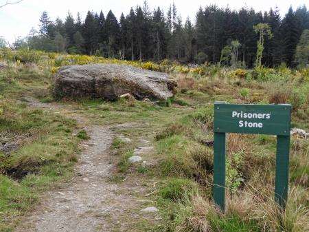
This walk takes in one of the most prominent objects outside the immediate arena, the Prisoners’ Stone, where 17 Jacobite soldiers are said to have been shot in the aftermath of the bloody fight that took place on this desolate moor on April 16, 1746.
The stone now lies within a felled area of Culloden Wood, and our walk uses lovely paths through the forest, as well as new roadside paths, to complete the historic trail, devised by the National Trust for Scotland (NTS).
I like to think I had some influence on this route myself because I featured a version of it in my first book, Walking and Cycling in Inverness and the Highlands.
Since that was published new roadside paths have been constructed where I described grassy verges and the whole trail has been promoted through the NTS visitor centre.
It makes a great walk and I enjoyed it again recently on a sunny spring evening. Birdsong filled the air as I strode onto the battlefield, contemplating how this scene of death and devastation for the Jacobites and their cause is now home to such an abundance of wildlife.
The main car park is locked at 6.30pm but there are spaces to park outside the barrier if you plan to be back after this time. From the main car park go under the walkway onto the battlefield and take the clearest path diagonally right, passing the red flags where the government forces stood. Go right, then left, to pass the mass graves and the memorial cairn – a poignant spot to reflect on the turbulent history of our country.
Continuing past the cairn you cross the line of blue flags that mark the position of the Jacobite troops and eventually reach a gate at the edge of the battlefield.
Marker posts direct you along the route from here and they’re mostly fairly straightforward to follow.
Go left here and soon take a right onto a forestry track which passes through a beautiful bit of woodland. The gorse was in full flower and young trees were bursting up in an area which was clear-felled a few years ago.
A right turn is marked at one of several new benches along the route, leading down to the B9006, after going through a gate and passing close to houses. A roadside path now leads left as far as Blackpark Farm, where you cross carefully and go down the farm track.
Take the second track left off this, not long before the main farmhouse, then look out for a path signed left to Culloden Wood through a new metal gate.
There are wonderful views over to the Beauly Firth for a few brief sections of the path here, and it looked glorious on this sunny evening.
Another gate leads into the woods where you stay ahead to pass the clootie well, known as St Mary’s Well. Cloths and clothes are hung on the trees nearby as part of an ancient Celtic tradition thought to cure sickness.
The battlefield trail goes right just after you leave the rags behind, following a beautiful forest route that winds and twists along the edge of the wood then cuts left to reach the Prisoners’ Stone. It’s sadly more of a drinking den these days than a respected relic of battle, judging by the broken bottles I spotted around its base. Not this evening though. There were plenty of families and dog walkers out just enjoying the peace and dry weather.
Turn right at the forest track and follow it past the forestry school, making sure to note any signs through the construction works for the new college buildings.
I couldn’t spot a trail marker where you emerge at the road above Balloch, but the route goes right here and, again, a new roadside path now goes all the way up to the junction with the B road.
It’s possible to detour to visit Cumberland’s Stone by keeping on the left-hand side of the road at the top and crossing over.
This massive glacial erratic is where "Butcher Cumberland" is said to have stood to command his troops during the Battle of Culloden, though that version of events is disputed.
To return directly to the visitor centre, cross the road you have been following up the hill and a little path goes across the B road then follows an old track straight back to the access road for the battlefield.