


Happy as a pig in snow on winter walk
Register for free to read more of the latest local news. It's easy and will only take a moment.

Drawing a line on the map from the start of this walk to the viewpoint is a distance of around a mile – but you are made to work for that fantastic vista on this 14-mile out-and-back route which climbs high above Loch Ness.
The Great Glen Way skirts around the shoulder of Sron na Muic on its way south from Invermoriston to Fort Augustus but our route takes us up to the summit of the hill, 488 metres above sea level.
The crags which shoot up from the depths of Loch Ness below and surround the front of the hill – whose name translates as “nose of the pig” from Gaelic – means it’s a long walk around the base of the peak before the climbing starts.
This is no hill walk in the true sense of the term, though, as it climbs to a communications mast at the summit following forest tracks the whole way.
The information board at the car park tells you it is possible to cycle this route – normally that would be true but not in the conditions I encountered after a cold couple of winter days in the Highlands. The A82 was only just clear of snow, but from the outset the trek involved walking through the white stuff, adding a lot of extra effort to what is already a strenuous day out.
With grey clouds still hovering menacingly above as I arrived in Invermoriston, I donned the full waterproofs from the start, crossing the main road from the car park and going left to cross the modern road bridge.
This gives a great view of the old Thomas Telford bridge, now in a slightly ruined state but still crossable on foot with care.
Over the river, turn right, following the Great Glen Way sign towards Dalcataig along a minor road.
Even this flat early section was harder work than it would normally be due to the snow, so I knew it was going to be a long 14 miles. The information board suggested allowing five hours for the return trip – I took six in these conditions and that was marching along when I had the chance!
Ignore a Great Glen Way marker post pointing left into a recently cleared area of forest and instead stick to the road ahead, which continues to eventually reach a forest gate, which you continue through.
Another Great Glen Way marker soon points left, part of what used to be the cycle route before that was scrapped. Ignore this one as well and stay straight ahead to follow the line of the River Moriston, which you go close to in stretches and can see its wonderful little rapids.
As the track starts to climb, stay left at a fork to keep going uphill and soon cross a new bridge before continuing to what is marked as a crossroads on the map – however, the right turn appears to now be overgrown and unused.
The track to the left here was going to make up part of my return route but a clear Forestry Commission notice stated there was an unsafe bridge, not even suitable for pedestrians, so that meant a change of plan for the return journey.
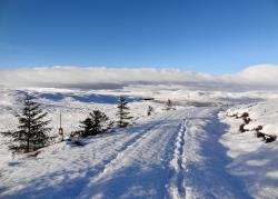
There was still a long way to go to get to the top, though, so I continued straight on up the hill. At the next junction, take a left turn and follow this track as it goes right to climb higher still (ignore the grassier track that goes left on the bend). As I got higher I could now appreciate what benefit all this climbing had – the views were beginning to open up and, looking down Glen Moriston, I could soon see the snow-capped mountains of Strath Cluanie, many of which I have enjoyed climbing in similar conditions.
A hairpin left bend ahead offers a substantial viewpoint down the glen in itself but I still had a good two-and-a-half miles to reach the top of Sron na Muic, and I was already tiring after trudging through the snow, which was inevitably getting deeper the higher I got.
Follow the hairpin bend round and keep left as the track immediately forks. There’s a fairly flat section now as the track contours around the edge of the hill with occasional tantalising glimpses to the snow-covered tops poking out above the trees.
Then the climbing begins again, and it seemed an age until I finally reached the edge of the forest, marked by two large wooden gateposts (the gate itself looked long gone, as there was no sign of one). I don’t think I’ve ever been so happy to see a communications mast ahead of me on a hill!
Out of the shelter of the trees, the wind was biting cold as I battled up the last mile or so to the mast, hoping the view would be worth the effort in this weather.
Eventually I got there and took in the moody view down the Great Glen, with Loch Ness looking grey below the dark cloud and white snow. Still, I could see over Fort Augustus (making out the Corrieyairack Pass) to Loch Oich and even as far as Loch Lochy. The nearby summit of Burach framed the view nicely, while to the north I could see Meall Fuar-mhonaidh, that prominent hill best reached along a minor road from Drumnadrochit.
With little sign of improvement in the weather – and the extra time I had taken to get up here – I decided to head back down pretty quickly. But as I rounded the corner, the sun broke free from the oppressive cloud and bathed everything in glorious light. The landscape was transformed, as was my mood, and this rather bleak hilltop suddenly seemed a more welcoming spot.
Surely this change in fortune was deserved after a seven-mile uphill trek? At least on the way down I had my own footprints to follow, having beaten a lone path through the snow on the way up. Next time I might just bring the bike to reach this impressive viewpoint!