


From Jacobite stone to royal cairns in the Cromdale Hills
Register for free to read more of the latest local news. It's easy and will only take a moment.

WINTER MOUNTAIN WALK
Cromdale Hills
Distance – 16kms
Terrain – Tracks and moorland
Maps – OS Landranger 36, Grantown and Cairngorm; OS Explorer 419, Grantown
Start/finish – Cromdale car park off A95
A walk over high moorland best done either when the ground is frozen or after a dry spell in summer to avoid boggy terrain
THE solitary stone sits alongside a couple of lonesome pines on a track high above the village of Cromdale on Speyside.
Marked as Clach nam Piobair – the Piper’s Stone – on the map, it is linked to the Battle of Cromdale in 1690.
Jacobite forces, led by Major-General Buchan, who were camped at the Haughs of Cromdale, were routed in a surprise attack by government soldiers commanded by Sir Thomas Livingstone, the garrison commander at Inverness.
Legend has it that a Jacobite piper stood on the stone, playing tunes to urge his men on until he finally expired.
True or not, the tale adds a little romanticism to a walk on the Cromdale Hills, which form a long moorland ridge stretching for over 10km, dividing the straths of Spey and Avon.
This can be rather soggy territory but, with a hard frost the night before and the freezing level at around 500 metres, I knew the wet stuff would be solid.
My walk began in the car park at Cromdale, on the west side of the A95 opposite the Haugh Hotel.
A minor road to the right of the hotel is level at first, passing close to houses then rising to a left-hand bend and, on the right, a track with signs to Lethendry Castle, the Piper’s Stone and a viewpoint.
The main track to the Piper’s Stone goes through Lethendry farm but I continued for a short way to view the remains of the castle, adjoining some farm buildings, then on up to the viewpoint on a little knoll.
Speyside stretches out before you here in a wide vista back towards Grantown. Immediately below is Balmenach Distillery, established in 1824 and now run by Inver House Distillers.
Whisky is produced here using traditional methods and machinery.
Looking down on it I could have done with a nip now a biting cold wind was blowing.
I descended through a field to meet the track that curves around Claggersnich Wood, gaining height as it does so and steepening quite markedly before levelling off.
The Piper’s Stone is on the left, as the track starts to descend again.
I took a break here, sitting on a rotten tree trunk and looking over the countryside before heading up towards the ridge, passing grouse butts on the frozen path, which was rock solid with no give in it at all.
Grouse flew up every now and then as I disturbed them, while lower down hares had helter-skeltered about the fields.
In a kilometre the path reaches a large, cigar-shaped cairn, visible from the foot of the strath. This is the Coronation Cairn, built to commemorate the crowning of King Edward VII and Queen Alexandra at Westminster Abbey in 1902.
By now I had reached the snowline and a frozen white blanket separated me from my objective, Creagan a’ Chaise, around two kilometres south of the cairn and the highest of the Cromdale hills at 722 metres.
The wind was even colder at this height so it was time to batten down the hatches. I pulled the hood of my soft shell jacket over my hat and the hood of my waterproof jacket over the top.
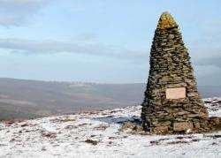
Still it felt bitter so I set a brisk pace across the snow, first into a shallow dip then a gentle climb and a sharp final rise to Creagan a’ Chaise, marked by a trig pillar and a magnificent, two-tiered circular cairn.
This one was built to mark Queen Victoria’s Golden Jubilee. A plaque (left) set into it is inscribed with the date, June 1887, and “God Save The Queen”.
I was thankful of this royal protection from the wind to sit and enjoy a drink and a bite to eat. After a fine morning, cloud began to roll in so I made tracks back to the Coronation Cairn and down to the track above the Piper’s Stone.
A wind farm on the hillside across the Spey blighted my view on the return to this point. It is becoming increasingly difficult to find a hill that doesn’t have one of these monstrosities in sight.
To make a circuit of the walk, instead of going back the same way to Lethendry, I followed the track north, turning left at a junction to reach the minor road back to Cromdale – three kilometres away.
I made a mental note to bring a bike and leave it here the next time I do this walk, for a more speedy return.
Back at the car it was 1.30pm and I’d been out for five hours. The early start had been worth it, not only because the rain was on now but also because at 3pm I wanted to see Wales play Ireland in the Six Nations.
Even better when the reds came up trumps with a late penalty in what had been a thrilling game.