


Following the Findhorn
Register for free to read more of the latest local news. It's easy and will only take a moment.

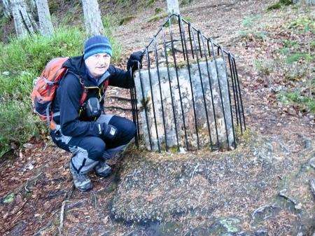
FLOODS are nothing new. While Britain has been wracked by storms for weeks there are historical precedents for events like these. Back in August 1829 incessant rain caused the River Findhorn to rise to a height of 50ft above its normal level in Moray, in an event known as the Muckle Flood.
It’s difficult, standing at the floodstone which marks the height the river reached, to imagine what it must have been like - the raging torrent foaming down towards Findhorn Bay, between Nairn and Forres, leaving havoc in its wake.
Close by is Randolph’s Leap, where the river is squeezed through a gap only 10ft across. I’d reached it on a lovely walk along the edge of the Findhorn gorge, starting from the Sluie car park alongside the A940 south of Forres.
The gorge at Sluie has been an attraction since Victorian times and it’s easy to see why, given how attractive it is. From the car park we took the track that leads to Mains of Sluie farm and turned left at an obvious signpost inscribed Sluie Walk. Before long a right turn takes you towards the river passing a sign warning of steep cliffs. The path descends then follows the edge of the spectacular gorge with the river flowing below. If you’re tempted towards the edge be wary – the drop is precipitous.
The well-made path passes through beautiful mixed woodland with a carpet of heather and moss beneath the trees.
Eventually the path reaches a wooden barrier and turns back the way you’ve come. You can return to the car park for a short circuit, but it’s possible to bypass the barrier and carry on along the edge of the gorge.
The path is mostly easy to follow and further on drops down to the side of the river for a time, getting you much closer to the water. I wondered whether it would be possible to walk as far as Randolph’s Leap and decided to persevere, staying with the riverside path.
Sure enough, closer to the imposing white facade of Logie House and the craft centre at Logie Steading, signs began to appear pointing the way to Randolph’s Leap. These paths are well signed and it’s quite straightforward reaching the arched stone bridge that carries the B9007 over the Findhorn.
We crossed the bridge then walked up hill and took the path on the right leading back to the river, the floodstone and Randolph’s Leap.
Retracing our steps as far as the signs around Logie Steading, we turned right following a Sluie Walk sign.
That led us on a gradual ascent through woodland back towards the Sluie car park. At a large Moray Estates sign with the forest paths mapped on it, we turned right on a driveable track. It passes a couple of fishermen’s bothies which are let out to anglers in season and soon reached our start point.