


Enjoying the quiet life in Sutherland triangle...
Register for free to read more of the latest local news. It's easy and will only take a moment.

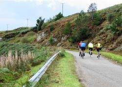
CYCLE ROUTE
Kyle of Sutherland loop
Distance – 35 miles
Terrain – Relatively quiet A roads plus very quiet minor roads
Maps – Any decent road map
Start/finish – Bonar Bridge
A triangle of tarmac offers a spectacular ride in the centre of the Highlands
I?love to explore the north of Scotland and for me there’s no better way than doing it on two wheels. This ride, which I first did a few years ago, is the perfect distance for a winter’s day when the light fades more quickly.
It begins at a nice parking area just on the Ardgay side of Bonar Bridge, though an alternative is to take the train to Ardgay and start the circuit from the station.
For those who cycle regularly there are no major hills on this all-tarmac ride and you can keep up a decent pace. Even for occasional cyclists this is an achievable day-long ride on quiet roads set in some spectacular scenery. I would definitely recommend it.
Turn right out of the car park, going over the bridge and then turning left towards Lairg on the A836. Despite the A road status, this is a fairly quiet and wide stretch of road. It leads you past the spectacular Carbisdale Castle – with its missing clock face shunning Sutherland – situated across a pedestrian bridge the other side of the Kyle of Sutherland.
This marks the point where you join the National Cycle Network (NCN) Route 1 towards Lairg, and you follow the blue bike signs left onto the A837 Ullapool road before soon going right towards the Falls of Shin on a minor road.
This road does get busy at times with people flocking to the visitor centre and to see the salmon leaping – not to mention anglers heading to the river to fish – but by now the rain had started and I only came across a couple of cars.
Despite the weather I had to stop at the falls to see if I could spot a few late leaping salmon. I waited 10 minutes or so and did manage to spot a few eventually. They are magnificent fish and you really appreciate the effort they make to get upstream when you see them trying to jump up the fast-flowing water here.
There is also a gift shop and café at Falls of Shin and, after putting a few Christmas gifts in the pannier, I continued up the single-track road following the course of the River Shin.
At a T-junction just before Lairg the route goes left, now on the A839 towards Ullapool. Again this A road hardly lives up to its status as it gradually climbs before dropping gently down again past Raven’s Rock Gorge and on to Rosehall, both of which are nice spots for walking.
I stopped at the community forest at Rosehall where there is a beautifully constructed log cabin with picnic tables and information on the area.
There are also a number of cycling and walking trails in the forest which I plan to explore for Active Outdoors in the not-too-distant future.
Today, though, the sun was out again and it was time to head on. A couple of kilometres beyond Rosehall a minor road off to the left is signed towards Inveroykel and Culrain.
Follow this road over a cattle grid and a flat bridge, then another cattle grid, before climbing up a short, steep section to meet the best road of the day. If I thought the main roads were quiet, for the next eight miles I didn’t see one other vehicle.
I had this fast-flowing back road with views over the Kyle of Sutherland and through the many forest plantations all to myself – apart from one thing, that is.
As I came around a corner there it was, sitting on a fence post no more than five metres from me – an enormous buzzard. It beat its wings and flew off as I pedalled on towards Ardgay.
I was soon back at Carbisdale Castle – the other side of the pedestrian bridge this time. The castle was built between 1906 and 1917 and is now a youth hostel run by the Scottish Youth Hostels Association.
Here you rejoin the NCN going south and pass Culrain railway station with its curious bendy platform.
Turn left at the junction a mile from Ardgay and go through the village, ignoring the NCN Route 1 signs, then turn left back onto the A836 for 1km to return to the car park at Bonar Bridge, where there are toilets and picnic tables, with fine views out down the Dornoch Firth.
It’s a fine circuit of the Kyle of Sutherland and a real adventure out into the wilds of the north.