


Culbin Capers
Register for free to read more of the latest local news. It's easy and will only take a moment.

THE seaside town of Nairn is a great spot for outdoor fun, with its long sandy beaches and numerous local paths and trails.
It’s also right next door to the incredible Culbin Forest, a huge area of dunes planted with trees in an attempt to anchor the sand in place.
A huge network of forestry paths makes this a great spot to explore on foot or by bike at any time of year.
The junctions in the forest are all numbered and a leaflet is available with a map of the tracks in Nairn (at the tourist information centre or the library) or at the main Culbin car parks at Wellhill and Cloddymoss.
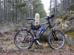
This cycle route begins at the harbour in Nairn and follows popular trails that lead to Culbin before returning on part of the National Cycle Network on quiet rural roads. Head around the harbour and cross the bridge, going straight on into the caravan park towards the east beach car park.
After a series of speed bumps the road bends left before you take a right turn at the end of the site down to the car park. A number of trails lead off from here to the beach but I followed the path at the far end of the parking area, signed to Kingsteps.
This excellent little path soon emerges from the thick gorse and bends right past Nairn Dunbar golf course. The trees of Culbin Forest come into view ahead as you cross a little burn.
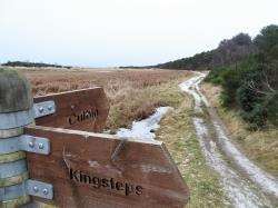
A signpost at the Minister’s Pool – where legend has it a minister once used to skate - directs you straight on towards Culbin, with the Kingsteps route off to the right offering an alternative link to this route from the car park there. The path is less well made from this point and there was still a fair amount of ice on the ground on my visit, though this was starting to melt and leave patches of very boggy ground to pedal through.Once you’re alongside the trees there are a number of ways into the forest. I stayed near the shore through the RSPB reserve until the ground became too soft, then followed an initially sandy track up to junction 23 in the forest.
Turn left here and follow the easy track to a T-junction (22). Go right, then stay straight ahead at 24 to pass the north side of the otter pool, a man-made pond to help attract wildlife to the area.
You can not only see otters here (if you’re lucky!) but also roe deer and countless species of birds.
Back to the track – sometimes bumpy, sometimes muddy but generally fine to cycle on a hybrid or mountain bike - at junction 28 go left, then keep ahead at 29 and 20 to reach the shore on a sharp right-hand bend. It’s worth going down to the beach here for a look at the birdlife in the nature reserve before following the track inland. Go straight on at junctions 19, 31 and 32, then fork right at 34 and straight past 33 to reach a gate. This takes you round a bend and up to the Cloddymoss car park.
I find Culbin is perfect for cycling or running. If you walk, the long tracks mean you need to keep going for a long time to get anywhere! Having said that, the Hill 99 trail - featured in Active Outdoors in November 2008 - is a great little trek and offers fine views from the top of the tower.
From the Cloddymoss car park, follow the forest track out towards the road and turn right at a crossroads near some houses.
When you reach the road turn right and keep straight ahead at the Brodie Castle junction. A little further on you pass a National Cycle Network milepost on the left-hand side, then fork right at a sign to Nairn, still five miles away down this wonderful country lane.
There are great views left up into the Nairnshire moors and right over the Moray Firth to the Black Isle, as you pass through farmland and a Christmas tree farm on the way west.
At Kingsteps you have the option of turning right at the bottom of the little hill to follow the access road to the car park, then a track down to the signpost you passed earlier or, like I did, continuing on cycle route 1 towards Nairn.
After entering the 30mph limit in Nairn go past the golf course, then look out for a blue cycle sign pointing right down a residential street.
Turn right here and follow the cycle route down a tarmac path to cross a road.
Follow the path towards the Merryton Bridge and turn right just before it on the riverside trail which leads back down to the harbour bridge.
Route details
Nairn and Culbin
Distance 15 miles / 24 km
Terrain Minor roads, forest tracks and muddy singletrack
Start/finish Nairn harbour car park
Maps OS Explorer 422; Forestry Commission’s Culbin leaflet and map
A fairly flat ride on traffic-free trails and quiet roads