


Coming back down with a crash
Register for free to read more of the latest local news. It's easy and will only take a moment.


We’d decided to head east to get the best of the weather, but watching the showers lashing the windows of the Glenshee ski centre café wasn’t inspiring. The cloud scudding across the top of Meall Odhar meant there was time for another coffee to consider the day’s route in the eastern Cairngorms.
Looking at the map we decided to do Carn an t’Sagairt Mor, one of the outliers on the classic White Mounth circuit. Part of the appeal of heading into the hill from the west, via Loch Callater, was to avoid the congestion of the Glen Muick car park; the routes around the loch being an understandable tourist draw during the summer.
Logistics sorted, I looked up from the map to see blue skies appearing in the breaks between showers and Glenshee’s upper ski tows emerging from the cloud.
We drove down towards Braemar to start in the car park at Auchallater and set off along the estate track towards Loch Callater. There were several groups on the track dressed for a low-level walk, but there was less of the high street atmosphere often experienced on the other side of the range.
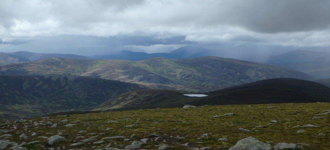
The approach to the loch is a decent 5km but with a good surface underfoot the distance passed (relatively) effortlessly and, just before some estate buildings by the loch, a stalkers’ path headed left up the hill. This climbed steeply at first then more gradually, treating us to grand views of Loch Callater below, its colour changing from steely grey to blue as the skies above cleared.
The accommodating gradient of the path meant that it was possible to keep up a good pace and, looking back, it was satisfying to see the height we had steadily gained. Apart from sheep lower down, the hill was quiet bar the occasional grouse exploding from the heather as we passed.
The path turned away from the loch and we could see the summit dome of Carn an t’Sagairt Mor ahead, its rocky slopes leading my eyes up towards the skyline.
The slope here steepened, the path taking us in zigzags upwards. We began contouring around the side of the hill and, as we were only doing the one top, we decided to follow the path to make a circuitous approach to the summit.
On the plateau the short grass gave great running and the peak of Carn Battock soon came into view ahead, followed shortly after by the cliffs of the White Mounth and the rounded summit of Carn a Choire Bhoidheach.
We had still not seen a single person since the low-level Loch Callater track and we were only reminded of the popularity of these hills when we reached a significant crossroads in the path, each way leading to a different Munro – a true bagger’s paradise.
We turned left to head up the steeper ground towards our summit goal and, as the ground flattened out, I followed the guidance of several cairns to soon reach the summit. To the west, showers moved quickly across the main Cairngorm plateau, curtains of rain obscuring each summit in turn.
Looking back to watch my running partner Eric crossing the rocky terrain to join me it seemed the clouds gathering at his back were racing him across the high ground.
We ate looking north, sheltered from the freshening wind in the lee of the cairn, the tors of Ben Avon looking pinpoint sharp and almost within reach through the clear air between the showers.
Refreshed, we started down the steep west side of the hill, making a direct line for the path up from the loch. Our progress was soon halted by almost tripping up over a large piece of aeroplane wreckage.
A Canberra aircraft crashed here in November 1956, during a night flying training sortie from RAF Upwood in Cambridgeshire, and large debris from the plane can still be found scattered near the top of the hill. Standing in the cool wind beside the aircraft remains, and knowing that the subsequent rescue operation took place in weather much more inclement than today, I had a brief feeling of remoteness and vulnerability at being high on the mountain.
Following old metal fence posts down the hill, some adorned with aircraft wreckage, we soon met the main path up. Retracing our steps from the return route from here, the well-graded stalkers’ path made for a quick descent with little brain space for talking, but still a little time to look up Glen Callater to watch showers moving across the hills behind us.
The path deposited us abruptly back on the estate track at the foot of Loch Callater where it was time for a quick breather. After a couple of hours on the hill, the gentle downhill gradient helped ease the miles back to the car park and the straightforward going alongside the Callater Burn was a pleasant end to a day on the hill.
Route details
Carn an t’Sagairt Mor from Loch Callater
Distance 12.5 miles / 19.5km
Terrain Estate track, good stalkers’ paths, rough rocky ground higher up
Start/finish Auchallater car park, Glenshee (charge)
Maps OS Landranger 43 & 44; OS Explorer 52 & 53; Harvey British Mountain Map, Cairngorms and Lochnagar
A long but relatively gentle approach to a classic eastern Cairngorm hill with great panoramic views and some historical interest