


Climbing the Ladders
Register for free to read more of the latest local news. It's easy and will only take a moment.

THE Ladder Hills stand as a boundary between Strathdon and Glenlivet and I spend a lot of time here as the area is refreshingly quiet even on the sunniest summer Sunday.
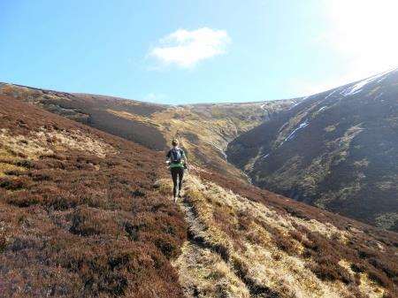
This run is one of the longer routes I do, taking in the northern part of the ridge. Although the navigation is relatively easy, the run is best enjoyed when the visibility is good and you are able to weave across the moor, finding the best ground.
Parking in the East Auchavaich car park in Chapeltown of Glenlivet I set off up the farm track, the fields either side full of lambs, some of which had escaped the confines of their fields and were exploring the lane.
Following their tails uphill towards the houses at Ladderfoot, the farmland soon turned to low moorland, a mixture of heather and juniper bushes.
After crossing a ford, with a handy bridge for those on foot, I turned right to follow a stalkers’ path up the side of glen. The path follows the left bank of the Ladder Burn before starting to gradually climb the side of the hill.
This path is an old way over the mountains. Originally a coffin road, it was then used by whisky smugglers to take their uisge beatha to those with a drouth in towns as far afield as Aberdeen and Perth.
There is still an air of being in a hinterland in this part of the world and, although the hills are intensively managed by tenants of the Glenlivet Crown Estate, there is an emptiness about them, one in which wildlife thrives.
The bealach at the top of Ladderfoot is a regular haunt of golden plovers and I paused at the cairns that mark the boundary between two counties to look across to the distinctive tors of Ben Avon on the eastern skyline.
I headed left, along the southern side of the ridge where a worn path contours along the side of the hill. The path becomes faint at times, but the odd boot imprint keeps you right.
Keeping the ridge to my left, I crossed a stream, passing infrequent small cairns on the now broad slope. Skirting the summit of Little Gael Charn I soon met a sturdy fenceline, easily crossed, and joined a Land Rover track coming up from Strathdon. This leads north-east to the summit of Gael Charn, marked by a diminutive pile of stones with a fence post sticking out of the top.
Heading east to rejoin a distinct track I continued north along the ridge, the easy running giving time to enjoy the expansive views to the east into Aberdeenshire. Having run this route before I knew the best option was to give up trying to follow the paths marked on the OS map and cut over the ridge towards Round Hill, cutting out at least some of the really rough going.
I could see Round Hill ahead of me, but unfortunately this section of the run becomes a lesson in sustaining morale. The pathless ground soon goes from forgiving short heather to deep labyrinthine peat hags. I kept the high ground on my right, an intermittent deer path giving a sense of purpose, even if the going on it was probably as rough as off it.
I looked up at the skyline above to see a mountain hare posed perfectly, alert for danger, and rightly so – merlins and peregrine falcons are among some of the resident predators.
Inspired by the hare I decided to head for the ridge to see if the terrain improved at all. It didn’t, but the reward was a new view north towards Corryhabbie Hill and Ben Rinnes.
Joining a fence on the ridge I lurched though bogs, ungracefully tripping over tussocks but making steady progress.
Just before the final rise on the ridge I spotted a large peat runnel heading down in my direction and tore down it enjoying the soft, easy going, finishing mud-covered but invigorated at the bottom from many harmless slips and tumbles.
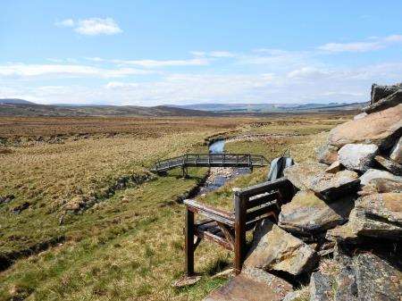
A herd of deer lower on the hillside bounded for the same distinctive notched bealach as me that marks the path down towards Glen Suie. Another fast descent over heather deposited me on the banks of the Kymah Burn, and I followed it until Suie Bothy.
This is a perfect lunch stop, complete with a bench for two facing down Glenlivet. I stopped to enjoy the solitude in warm sunshine, entertained by wheeling lapwings, their sharp cries loud over the sound of the burn.
Crossing the burn I passed the confluence that is the start of the River Livet and joined the waymarked Malcolm Gillespie Smugglers Trail. Gillespie was an exiseman in the 19th century and the route marked out by the Glenlivet Estate follows ways along which he would have pursued whisky smugglers.
The track leads back round into the farmland surrounding Chapeltown of Glenlivet, the final short stretch on the road surprisingly hard work for legs tired out by the hill.