


Chugging along on old road and rail routes
Register for free to read more of the latest local news. It's easy and will only take a moment.

CYCLE ROUTE
Fochabers circular
Distance – 26 miles
Terrain – Minor roads and B roads; cycle path; steps; busy A road crossings
Maps – OS Landranger 28 or OS Explorer 424
Start/finish – Fochabers – parking available at village square, public toilets (except at school bus times) and on Ordiequish road
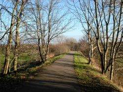
A varied road ride in Moray visiting Spey Bay before taking the high road return
Villagers in Fochabers and Mosstodloch were celebrating last week when a long-awaited bypass was opened, taking traffic off what used to be the A96.
The relatively deserted main road that links the two Moray villages is now a joy for cyclists – and the finishing touches are being put to excellent traffic-free cycle links too.
The fencing and cones of the final throes of the roadworks made for a slightly confusing start to this excellent ride, but it was clear that once the cycle path is completed it will only get better.
Fochabers is now easily accessed off the new bypass and there are a number of places to park in the village. I opted for the area beside the sports pitches and public toilets, down East Street towards Ordiequish, though if you’re there during the week parking is restricted to allow access for the school bus.
I set off on the bike back up to the main road through Fochabers and turned left. As you leave the high street, a rather confusing cycle sign directs you left to Mosstodloch but I found the best option was to just join the roadside cycle path here and continue round the corner to cross the old bridge over the River Spey.
This leads you to a new cycle path between a couple of houses, though the tarmac soon ran out and I had to join the bypass for a very short stretch to a roundabout where a right turn leads into Mosstodloch. Very soon the cycle path should take you into the village without having to do this.
Once into Mosstodloch the riding was a pleasure – without the bulk of the traffic that used to pass through here – and I turned right where a signpost points to Essil on a very quiet road that runs parallel to the Spey.
As I left the houses behind, the yellow gorse – already in flower – lined the road and I delighted in that rare commodity, sunshine. It had been a while since I’d had a day like this on the bike, though that was to change all too soon.
Approaching Garmouth, a Sustrans cycle sign points right down some steps (you’ll need to get off and push here!) to meet the old railway line between Elgin and Buckie. These days it’s a tarmac cycle path that goes over the fantastic iron bridge across the meandering mouth of the Spey.
The route goes right where this meets the B9104 but I decided to take a detour to Spey Bay first, returning off-road on the Speyside Way back up to the cycle path.
After going right onto the B road, take the next left just after a house where National Cycle Network Route 1 is signposted, then turn right at a T-junction in Nether Dallachy. Keep straight ahead at a crossroads where the cycle route goes left, and further on cross the busy A98 to follow a sign opposite to Keith.
This part of the route goes through glorious countryside but a horrendous headwind made it a real struggle for me. I finally reached the B9016 as it begins to climb south towards Keith and, as I got higher, so the weather got worse. My sunglasses were soon covered in rain and the wind was getting colder.
When I finally reach my turn-off, marked by an interesting old sign pointing to "Crossroads 1?", there was ice to be found at the edge of the road. I still had a little more uphill to contend with too but it was easing now and the road reaches its highest point in the forest before dropping down to meet the A96.
Carefully cross this busy road and continue on a minor road all the way to Mulben, where you cross a burn then the railway before arriving at a crossroads, turning right onto the B9103.
Just after a row of houses at Craighead, go right down the hill onto a minor road that’s signposted (from the other direction at least) as a cycle link to Ordiequish. The spectacular road crosses the railway and the burn again before climbing via a superb hairpin bend in the trees and eventually meets the Speyside Way on another minor road.
Turning right, this one leads directly back to Fochabers and offers great views over the Spey valley. But there’s one little surprise in store before you get there – the craziest bit of tarmac I think I’ve ever seen!
At Aultdearg, the road drops steeply down to a tight hairpin bend at the bottom before climbing up the other side just as steeply.
I was going tentatively enough as it was with patchy ice on the surface, and it didn’t help when a car came the other way along the narrow single-track road.
I managed to stop and let it pass before easing my way to the bend. Going back up was, in some ways, easier but I was glad of an excuse to stop once I got to the top.
There’s a forestry car park at the Earth Pillars, from where you can take a short stroll to a fine viewpoint over the River Spey.
After enjoying the brief respite from the saddle, I continued up the Ordiequish road back to my car at Fochabers. What started as a sunny ride to the coast ended up as a tough ride in freezing conditions – but a route to remember for the brighter days ahead.