


Chasing waterfalls
Register for free to read more of the latest local news. It's easy and will only take a moment.

THE ascent looked incredibly steep. We had just parked at Loch na Gainmhich on the road between Skiag Bridge and Unapool in Assynt. Cloud swirled around the summit of Glas Bheinn, the Corbett we were about to climb, and from this perspective the nose of its north-west ridge was not going to be easy.
Experience told me, though, that closer inspection would reveal a reasonable line. A path branches off the road to the left, just south of the car park, and as we walked towards the base of the hill I could see a grassy rake splitting the rock.
It proved to be the way up, and although fairly steep posed no difficulties even for Rosemary, who is not at all fond of steepness.
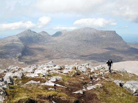
It ends on a shoulder of the ridge with more climbing to do before the 776 metre summit. Clear weather gave us a fantastic view north across Sutherland’s rugged landscape to
the sea.
But the dominant feature, on the opposite side of the A894, was Quinag. The sun had lit up its network of tops by now – which offer a strenuous day out if you do them all.
I walked to the eastern edge of our ridge to get a look down at Loch a’ Choire Dheirg and spotted the path continuation up Glas Bheinn.
It’s composed of greyish-white gneiss scree at first but turns to earth and grass, then more rock before a prominent cairn is reached, perched right on the edge of Coire Dheirg.
From here we took a direct line south for the summit then carried on towards a narrow spur that drops to the bealach between Glas Bheinn and the huge grey mass of Beinn Uidhe.
A good path heads east from the bealach, winding down into a jumbled mass of lochans, burns, knolls and crags.
A visit to the highest waterfall in Britain – or the top of it at least – was on the cards for us before returning to our start point.
Eas a’ Chual Aluinn plunges over a cliff into Glen Coul, and when in full flow is over three times higher than Niagara Falls. It’s best viewed from Loch Beag, below. But enjoying the easy pace and the sunshine, I somehow missed a path junction which would have taken us on a circuit west and the way back, with a detour to the top of the waterfall.
Realising my mistake we backtracked, but for the life of me I couldn’t find the path junction.
Knowing how to correct an error is half the challenge of navigation and I knew we should be heading for the prominent top of Cnoc na Creige.
Abandoning thoughts of visiting the waterfall, I took a bearing on Cnoc na Creige and we proceeded to cross rough ground, which was surprisingly easy to negotiate and looked as though others had done the same, before arriving at the eastern end of Loch Bealach Bhuirich and our path out. I could see two other walkers, who had obviously been to the waterfall, already well on along it. But for us Eas a’ Chual Aluinn would have to wait until another day.
The path back to Loch na Gainmhich is rough at first under Cnoc na Creige. It eventually levels off to cross some boggy ground.
We made for the outflow from Loch na Gainmhich, where stepping stones cross the top of another waterfall, before covering a short stretch of rough ground to the roadside.