


Along the glen to reach the Ben
Register for free to read more of the latest local news. It's easy and will only take a moment.

THIS magnificent coast-to-coast journey takes you the length of the Great Glen, starting in Inverness and ending in Fort William.
It’s a popular route with tourists, but those of us lucky enough to have this on our doorstep can really make the most of it, experiencing the glen in all seasons and different conditions.
It’s a tough route to do in a day as it climbs and drops steeply on some rough terrain in parts – but it makes for great off-road cycling.
Even if the thought of more than 70 miles in a day seems impossible, don’t worry. The Great Glen Way (GGW) is neatly divided and doing it over two or three days makes for a more leisurely ride, with some seriously hilly sections to tackle, especially along the length of Loch Ness.
We opted for an early start as part of our plan to get to Fort William in a day, joining the GGW on the west side of Inverness as it passes Great Glen House (Scottish Natural Heritage’s headquarters) near New Craigs hospital.
We picked up the path as it climbs alongside the Dunain Community Woodland to join the old drovers’ road behind the masts of Dunain Hill. This early bit of climbing gets the heart beating first thing in the morning and we were thankful it was overcast and cool, as well as dry.
It wasn’t long before we had left the city of Inverness well behind us as we followed the blue wooden signposts, marked with a thistle logo, to Blackfold. Here you can either continue on the path or take advantage of the tarmac to speed things up a bit. Heading up forestry tracks through Abriachan you reach the highest point of the GGW, marked with a sign at the side of the track. I’d like to say it was all downhill from here but that would be far from the truth!
However, the route does descend, on some bumpy forest tracks and a couple of miles of single track – impossible to cycle in parts – before turning right for a short stretch on the A82 into Drumnadrochit.
But it’s not long before the next climb – a challenging one up the minor road towards Grotaig. We stayed on the tarmac here rather than following the GGW signs along the River Coiltie, then steeply up through the forest to rejoin the road, though the surface on this off-road section makes it a rideable choice too.
The GGW then follows the road all the way to Grotaig, where an old sign for the now defunct Great Glen Cycle Route takes you downhill on a grassy but solid descent. Just as you begin to appreciate the break you reach the bottom and turn right on to a forestry track which climbs frustratingly back uphill.
Through the Creag-nan Eun Forest between Grotaig and Invermoriston the route rises and falls along tracks and nice sections of single track, with views over Loch Ness to Foyers, before you drop right down to near the youth hostel at Altsigh.
Then, you guessed it, back uphill again and there’s another nasty climb – on lovely single track this time – before the final steep descent into Invermoriston.
Just after crossing the bridge we turned right on to a minor road. The old GG Cycle Route (marked on my Footprint map of the GGW) suggests going all the way to Dalcataig before taking to the forestry tracks.
Instead, we just followed the GGW signs up a newly surfaced path, cutting a couple of miles off the day’s total – but adding another steep climb.
This part of the route goes through more forest but now, as we passed the popular walking spots of Rubha Ban and Allt na Criche, we could see the end of Loch Ness getting nearer and nearer.
We knew that once we had reached Fort Augustus the hardest part of the day – and the worst climbs – would be over. The sun was burning brightly by now and the sun cream was pouring off quicker than we could top it up, so Fort Augustus was a welcome sight as we rolled in for a long lunch stop.
Rested and refreshed, we filled our water bottles and headed along the Caledonian Canal past Kytra Lock and Cullochy Lock to Bridge of Oich.
Here, you’ve got a choice – the route through Invergarry or pedalling along the other side of Loch Oich which runs parallel to the former Great Glen railway line. Sustrans is currently redeveloping the old line here to create what will become a stunning route through the trees above the loch.
This time we opted to go through Invergarry along the forest tracks and saved the far side of the loch for our return journey.Beyond Invergarry the route follows the minor road right, towards Mandally, for half a mile before taking a sharp left on to a forestry track again.
At the top of a (relatively) short climb there’s a picnic table with fantastic views back up Loch Oich and Loch Ness.
Once you reach the end of Loch Oich you skirt the edge of the A82 – but instead of going on the main road, stay right and go immediately right on to the minor road, following a Scottish Rights of Way sign to Clunes.
The tarmac takes you past Laggan Locks (where the alternative GGW route via the old railway line rejoins ours) to Kilfinnan Burn, where a steep but thankfully short rocky climb marks the start of the track through South Laggan Forest and Clunes Forest.
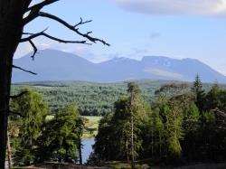
This section isn’t that hilly, though one or two areas are very bumpy, as it hugs the shore of Loch Lochy, offering tantalising views down the Great Glen and across the water to Ben Nevis, which still had snow clinging to its northern corries.
Eventually we came to the forestry car park at Clunes, going left on to the B8005 all the way to Gairlochy which, after 60 miles or so, we decided was much better than trying to ride along the GGW footpath which weaves its way through the forest, criss-crossing the road.
From the peaceful looking Gairlochy, it’s an easy ride along the Caledonian Canal all the way to Neptune’s Staircase at Banavie, Fort William. It’s worth pausing at Moy Bridge, the only remaining original swing bridge still in use along the canal.
From Neptune’s Staircase we followed the shared-use path and crossed the A830 to reach the sea locks on the west coast at Caol.
Then we kept to the GGW signs around the bay, past Old Inverlochy Castle and finally made it into the heart of Fort William after an exhausting but exhilarating day on the bike.
It was a beautiful evening and the water of Loch Linnhe was perfectly still, like a mirror. Now all we had to think about was getting back home to Inverness. But that’s a whole other bike ride!