


A testing time on Carn Breac
Register for free to read more of the latest local news. It's easy and will only take a moment.

THERE are times when you make decisions about a route you later wish you hadn’t. What seemed like a good idea at the time turns a walk into something more akin to an assault course.
So it was on Carn Breac – a Graham on the now notorious Ledgowan estate on the north side of Glen Carron.
At 678 metres the hill is usually tackled along with neighbouring Graham Beinn na Feusaige, though the two are more than four kilometres apart.
John and I had been over Beinn na Feusaiger on the day of an access protest at Ledgowan, whose owners have made themselves less than popular by attempting to impose rigid rules on walkers exercising their legitimate rights.
But Carn Breac was left out, so it was time to fill in the gap.
Rosemary and I set off from the bridge that crosses the Allt Coire Crubaidh on the A90, south-west of Achnasheen.
A track soon gives way to a boggy path through heather and juniper heading towards Carn Breac, clearly visible on the skyline ahead. On the way we passed an old Larsen trap. Legal in the UK but banned in Denmark, their country of origin, they are used by keepers to control corvids. The process involves keeping a live decoy bird inside the trap to attract others, which are killed. But the traps have also been know to catch raptors.
The path through the glen is shown on the map to divide in its higher reaches, though the line is indistinct and difficult to follow on the ground.
We climbed the hillside to a col between Carn Breac and the subsidiary top of Meallan Mhic lamhair.
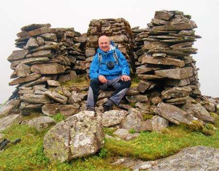
From there a ridge is followed south-west to the summit of Carn Breac, marked by a trig point inside a walled shelter, built so close to the trig point it’s impossible to take refuge from the wind.
What should have been a magnificent view north towards Torridon was obliterated by thick cloud and rain. We ate lunch and got ready to move on.
As a way of varying the walk and making a circuit, I’d decided to return along the ridge on the south side of Coire Crubaidh.
It looked perfectly feasible on the map, dropping in stages over two named shoulders – Coille Bhan and Coille Bhreac.
Navigation was needed to get off Carn Breac but after 15 minutes or so we dropped below the cloud and I could see our ridge.
The ground is rough and pathless but posed no difficulties as we pressed on to Coille Bhan. The midges were out in force, though, so stopping for long wasn’t an option.
On the descent from Coille Bhan, however, the ground got less even, was saturated and pocked with peat hags.
A deer fence loomed but an open gate made passage easy. Lower down I spotted a gate in another deer fence but it was locked so we clambered over.
Then it was down through thick undergrowth to reach yet another deer fence that had to be scaled.
There are a couple of bridges over the Allt Coire Crubaidh but the river was low enough to cross and we made a beeline for the track leading back to the car, to be greeted by clouds of voracious midges.
To avoid the purgatory I’d advise either returning the same way off Carn Breac or bearing round into Coire Crubaidh and picking up the left arm of the outward path. But be prepared for some very soggy walking!