


A steep descent into ancient Black Isle history
Register for free to read more of the latest local news. It's easy and will only take a moment.

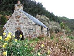
The old fishermen’s bothy with the rusty winch beside it.
WALKING ROUTE
EATHIE HAVEN
Distance — 2 miles
Maps — OS Explorer 432, Black Isle
Start/finish — Parking area on minor road between Rosemarkie and Cromarty before Eathie Mains (Grid Ref NH769636)
Reaping the rewards of fossil hunting on the foreshore after a steep descent
WHAT goes down must come up, or at least that’s the case here. This great walk certainly takes you a long way down, descending steeply through pine and spruce trees to emerge on the beach at Eathie on the Black Isle.
This is a walk I’ve wanted to do since I first passed this way whilst following the cycle route from Inverness to Cromarty. It always looked an intriguing little route down through the cliffs to the shore, with the promise of fossils to be found as well.
As a teenager I studied geology for a few years at A-Level, so the prospect of fishing for fossils on the foreshore offered an added incentive for me.
I took the car to the start this time, parking in the small parking area at the edge of the forest plantation a short distance before Eathie Mains. There were a few people already here, despite the overcast morning.
I got my boots on and took a look at the information panel, which explains how the 18th century geologist Hugh Miller spent much of his youth here searching for fossils. The foreshore is now a site of special scientific interest and you are asked not to hammer at the bedrock, but you can collect fossil debris among the loose stuff — if you are lucky enough to find some.
The walk begins by following the outside edge of the forest with a superb view out over the Moray Firth. It is level at first, turning to keep in line with the fence before passing close by a nice little pond on the left.
Shortly after this pond the gradient changes and the now well-built path begins its drop through the trees. This route was regularly trod by the salmon fishermen of Eathie until as recently as 1984, when the fishing station on the shore here stopped operating.
At the bottom you can still visit the old bothy where they used to sleep when they worked on the station, as well as the winch to pull in the salmon nets.
The path now zigzags downwards, and I enjoyed listening to the birds singing their hearts out, reminding me it was truly spring, despite the lack of sunshine. Soon a brief opening in the trees provided a fine vista over the firth, taking in Whiteness and Fort George with a foreground of blossoming yellow gorse.
The path continues to drop fairly steeply, going left on a hairpin bend deep in the trees before offering a further view up the coast of the Black Isle.
Looking to my right, I noticed that suddenly I was almost down at sea level. Where you meet a path at the bottom, I turned right above the water to reach the old fishermen’s bothy.
Outside you can see the rusted remains of the winch and inside you can read more about the fishing station, the geology and the flora and fauna which inhabit this wonderful area.
I looked out to sea, imagining the giant nets cast out into the water — nets which were still being used when the Kessock Bridge was opened in 1982!
Next I plodded onto the beach and began my hunt for fossils. But with so many rocks, it’s hard to know where to begin. I picked up a few with no luck but, as I walked along the beach, I was hooked; I couldn’t stop picking up rocks and checking for fossils.
With the tide out, I followed the beach north towards the gorge where the Eathie Burn tumbles down, all the time having to remind myself to enjoy the superb views out to sea and not just stare at the ground searching for that perfect piece of sedimentary rock.
Finally I did manage to find some fossils, the best example being a few ammonites together on one piece of rock. Not the most pristine example I’ve ever seen, but perhaps the most satisfying having collected it myself.
I returned down the beach to the more modern building at the fishing station (I use the term loosely as this one is dilapidated) to a wooden sign which points inshore to Cromarty.
The path loops round the back of the ruin and meets the steep path back to the road. It’s a little tougher heading back up but there’s plenty of scope to pause and enjoy those magnificent views for a second time.