


City boundary mix-up could affect funding
Register for free to read more of the latest local news. It's easy and will only take a moment.

INVERNESS residents could be losing out on critical government funding because accurate population figures are not available, a city councillor has claimed.
The Highland Capital’s youngest elected representative, Richard Laird, said the lack of a modern city boundaries meant government agencies, third sector funders and even individual departments within Highland Council were relying on different maps when making key decisions.
Concerns have been backed by the council’s Inverness leader Ian Brown, who was aware of at least one instance where Inverness missed out its fair share of funding after the wrong figures were used by the Westminster government to calculate the population.
The council’s Inverness city manager David Hass acknowledged Councillor Laird’s point, adding an investigation into the city’s boundaries is now underway.
However, the Scottish government stressed its funding for communities was not solely based on population size.
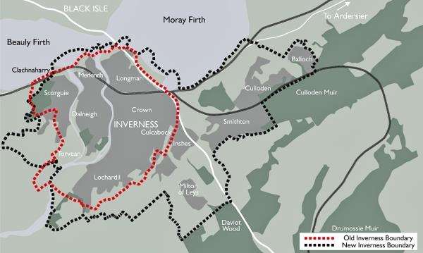
Two of the maps currenlty being used by the city’s officials are the Inner Moray Firth Local Development Plan, published last year, and the burgh boundary map, which dates from the 1970s. Councillor Laird, who claimed council officials were confused about the situation, has called for one official
map setting out a clear boundary of the city.
"I know of two different council departments that are using different definitions of the city," said the SNP representative.
"I want to know which parts of the suburbs — Culloden, Smithton and Balloch — are in the city."
He recalled how some council officials have openly admitted to him that they do not know where the city’s boundaries lie.
Inverness was excluded from urban broadband funding last summer on the basis of what the Westminster government admitted was inaccurate population figures.
To be eligible, they had to contain 45,000 households within their metropolitan area and Inverness fell well short with 24,570. But Perth has been included, despite having only 22,600 households.
"When we add all the areas together Inverness is way bigger, but Perth did take other areas into their boundary, while Inverness didn’t do that," Councillor Brown recalled.
"That’s one instance I can think
of, but there may well have been others."
Former Inverness Civic Trust chairman Bryan Longmore thought the situation was causing confusion over which parts of the city were entitled to a
share of the Inverness Common Good Fund.
The 77-year-old, of Midmills Road, Crown, called for the Inverness councillors to "bite the bullet" and define city area which does not include places on the outskirts.
Mr Hass said the city committee would be looking into the issue.
"When Inverness was created as a city, it was created as a regional city," he explained.
"No geographical boundary was
set. It only has the old burgh boundary which was set many years ago
and that is not a modern city boundary."
The city of Inverness area committee is expected to discuss a report on the situation later this year.
A Scottish government spokeswoman said the council’s funding settlement is needs based, with population a large factor.
"However, as Inverness is part of the Highland Council area, issues with the boundary of Inverness would not affect the council area’s settlement," she added.