


Taken by Forse
Register for free to read more of the latest local news. It's easy and will only take a moment.

MONKS, Vikings, noblemen and herring fishers all made their mark on this stretch of Caithness coastline at various points in history. Today, though, I had it all to myself.
I was striding out along the cliff-tops to the south of Lybster harbour on my way to Forse Castle, a dramatic ruin thought to be of Norse origin.
It was a fine spring morning as I left the car outside Waterlines visitor centre, close to Lybster’s pebbly shore. A wooden sign points the way to the Swiney Hill coastal viewpoint and the harbour makes an impressive sight as you follow the path up the steep brae.
The Viking name for Lybster was Hlidarbolstr ("homestead on the slope") and the grassy headlands on each side give the harbour a compact feel. Looking down at the tranquil scene it was remarkable to think that in the 1830s Lybster was the third busiest herring port in Scotland after Wick and Fraserburgh.
Fishing does still take place here, albeit on a much smaller scale, and a creel boat was making its way out to the glittering sea as I veered off the main path and took an offshoot to the Brethren Well.
This interesting relic has its origins in the sixth century when a community of monks lived in a Celtic priory nearby; another Norse name associated with Lybster Bay is Haligoe, or "holy goe".
The rocks, stacks and caves are spectacular as you reach Swiney Hill with its interpretive panel describing the wildlife and seabirds that can be seen from here. Just a couple of weeks earlier an amateur video of orcas heading north past Lybster had been doing the rounds on social media. I was not so lucky.
By now the path had given way to a rough track, boggy in places, and I had to watch my step as I descended to the sheltered bay of Achastle with its crumbling fishing station – another echo of the 19th-century herring boom.
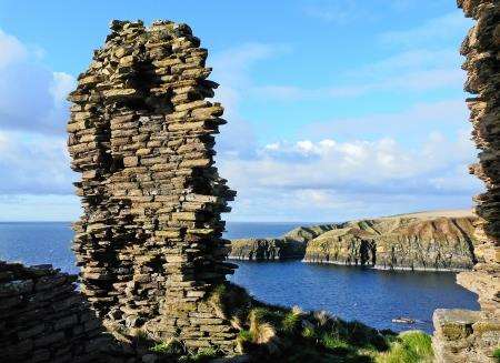
I used stepping stones to get across Achastle’s fast-flowing burn before picking my way up the steep incline on the other side and was soon back on the cliff-top trail. The scenery was magnificent: primroses and gorse all around, the unmistakable white walls of Dunbeath Castle in the distance, and, in between, the stark ruin of Forse on its towering peninsula.
Built around 1200, this was once a stronghold of Sir Reginald de Cheyne, a 14th-century nobleman of Norman descent, and became the seat of the Sutherlands of Forse for many generations.
With its drawbridge long gone, the castle looks from this angle as if it might be inaccessible – but, taking great care, I was able to make my way across the narrow, dipping approach to the entrance and have a look inside.
From the seaward side the shape of the ruin is strikingly similar to that of the Castle of Old Wick 15 miles up the coast, dating from about the same period.
Back on the main headland there was a handy way to reach the bouldery shore far below – by way of a rope tied to a sturdy wooden post. It’s not a vertical drop so it’s not as if you’re abseiling, but the rope is an essential aid to getting down and back up safely (just make sure you keep a good grip).The castle seemed all the more imposing from sea level. Venturing round a corner I came to the windowless, almost roofless shell of another abandoned fishing station. Inside, the fireplace was still blackened by the embers of a bygone era.
It was time to grab that rope and clamber back up the cliff. At the top I continued inland on a short track leading to a minor road that meets the A99 from Latheron to Wick.
I wouldn’t normally choose to walk along the verge of an "A" road but I wanted to make this a circular route – and there wasn’t much traffic about.
Away to the south, the Scaraben range was still topped by a layer of snow. Clouds swept in from the east, threatening to obliterate the clear skies of the early morning, and on the last half-mile to Lybster I felt the first few spots of rain.
The old bridge over the Reisgill Burn, just to the west of the A99, is a familiar landmark. What I didn’t realise until coming on foot is that there is a second bridge – smaller, and apparently older – on the other side.
The village itself was founded by local laird General Patrick Sinclair in 1802. Part of it was named Quatre Bras, in honour of a battle in which Sinclair’s sons fought two days before Waterloo, and this was where I turned right for the final mile through Lybster and down the winding road to the harbour, passing the tumbling Reisgill waterfall.
"Reisgill", by the way, comes from the Old Norse Hrisgil, or "brushwood ravine" – yet another reminder of those who walked this fascinating landscape long before us.