


Dry feet on the Fish Road
Register for free to read more of the latest local news. It's easy and will only take a moment.

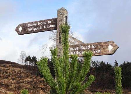
A SMALL wooden sign across the road from the Aultguish Inn on the road between Inverness and Ullapool says “Drove Road to Strathgarve”. The sign always provokes curiosity whenever I pass but it only tells a small part of the tale of this fascinating route.
The way through the Corriemollie Forest leads to Garve and the road was not only a drove route but was also used for carrying fish from Ullapool to market in the late 18th and early 19th centuries. It is marked on Arrowsmith’s 1807 map but the road had been superseded by the current route by around 1840.
Drovers, however, reportedly continued to use the route as a shortcut to keep cattle on soft ground with good grazing.
I decided to tackle this route from the south so, after leaving my bike at the Aultguish Inn – currently closed for refurbishment by the looks of it – I drove back to the car park off the A835 near Little Garve. It’s also possible to start beside Silverbridge on the opposite side of the main road where there’s parking and a picnic area.
A map board at the car park near the toilets shows the route, which begins by following the grass verge of the main road south to a forest track on the right. Follow the track for about 100 yards then go left on a track that climbs around the edge of the forest to reach a crossroads.
This is where you join the original drove road, turning right to follow a nice wooden sign towards Aultguish, climbing uphill with an open view over Loch Luichart to the west. If walking from Silverbridge, you join the route here rather than using the forest track from the roadside, though it does involve crossing the A835.

After a short section of track beside the trees you come to a high gate – locked on my visit. Not seeing any sign of a stile, despite this being a right of way, I had to climb the fence to continue on the route. The fence is pretty old and I suspect a stile could have fallen into disrepair rather than this being anything sinister – anyway, the climbing the fence option had certainly been used by others given the state of it.
Beyond, the way continues (with no further impediments) on a wet track more akin to a river than a road. It’s a theme that continues for much of the rest of the way to Aultguish and I reckon the fish could have swum to market themselves in these conditions! Decent footwear is definitely required and I was pleased my Gore-Tex boots held up well against a constant soaking – at least until the point I put my foot so deeply in the bog that the water went over the top instead. Squelch!
After heading through a few more gates below Creagan an Eich Ghlais you descend – for the first time – to pass the end of another forestry track. Ignore this and head down to your right to continue on the sometimes sodden route which dips then rises to cross a burn immediately before the end of the forest.
Emerging onto the open hillside you can now see over Lochan nam Breac to the crags of Carn na Dubh Choille. I stopped above the lochan and sat down to enjoy lunch and a warm drink while admiring the view to Little Wyvis and An Cabar on Ben Wyvis.
It was quiet and peaceful here and I imagined what it would be like for the drovers or fish merchants returning home – hopefully with bounty in tow – wary of any possible ne’er-do-wells lurking around the corner…
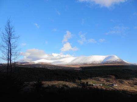
The path, still clear and slightly drier here, continues around the side of the hill before dropping to ford the Allt Bad an t-Seabhaig beside a small pool – large stones thankfully make for a simple crossing. A short track then rises to enter a young and spacious plantation of trees and I paused on top of the small rise to take in a fabulous view of Ben Wyvis, covered in a deep layer of fresh snow as the clouds started to lift from its slopes.
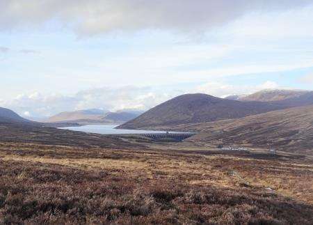
The route descends to cross the Allt Glac an t-Sidhean before rising briefly on a fainter path that deteriorates as it begins the long descent. Loch Glascarnoch comes into view, held back by that immense dam, and the Aultguish Inn gets gradually nearer as a fabulous view over the Black Bridge and Glascarnoch River opens up.
As you get lower, the way becomes less obvious but where it is most uncertain you should ignore a possible track right and instead continue to a gate ahead through a horribly boggy patch. Go through the gate to meet the next burn – the Allt Giubhais Beag – and follow marker posts downstream.
Here you can see a remnant of the original road in the form of the remains of a bridge structure. It’s amazing to think that 300 years ago this bridge was in use and formed part of the main route from Ullapool. Today just a few well-constructed stones are left on one side of the burn with evidence of a landslide on the far bank.
The route now cuts down to the main road opposite the inn, and I went to unlock my bike from the post I’d left it beside. As I was doing so, I saw a walker making his way down the main road and striking off when he saw the sign for the drove road – the first person I’d seen since Little Garve.
Tackling the walk north to south is perfectly possible but the first section across the bog beyond the gate would be awkward to navigate, as the path is barely recognisable as such in places.
To get back to the start, my ride would take me south along the A835. You can follow the road the whole way but I’d taken the mountain bike so I could visit a forest track I wanted to explore too.
After an easy downhill along the road from Aultguish to Inchbae, I entered the Longart Forest by a pedestrian bridge just beyond the Inchbae Lodge Hotel. Keep an eye out on the right-hand side along a straight section of road shortly after the hotel and you’ll spot the nice wooden bridge.
Cross the river here – now called the Black Water – and head up to a forest junction, where you go left on a stony forestry track. Low gears are required for a while but it’s worth it for what follows.
Around the top of the climb a truly spectacular view of Ben Wyvis was revealed from a gap in the trees, and the cloud had now lifted almost completely. All that remained was a long, mostly downhill ride through a delightful stretch of forest, emerging at the main road just south of the car park where the walk had begun.