


Bogged down in ancient history
Register for free to read more of the latest local news. It's easy and will only take a moment.

WHEN my front wheel began slipping and sliding one way and then the other, and I found myself plunging into mud-filled potholes that were deeper and stonier than I’d bargained for, it occurred to me that it might have been a mistake to try going across country.
I was aware the route would be boggy in places – it was winter, after all – but this was bordering on the inaccessible. And there was worse to come.
I’d cycled down the coast from Wick and turned off the A99 onto the minor road leading up to the Hill o’ Many Stanes. From here, continuing inland, the road gives way to a rough track that joins the Camster cycle trail – taking you through a conifer plantation to emerge on the Lybster/Watten road, just south of the Camster Cairns. It all seemed so straightforward in theory.
First I had a wander around the gently sloping hillside where 192 knee-high slabs dating back 3000 to 4000 years are set out in a series of rows. A Historic Scotland information board suggests the Hill o’ Many Stanes may originally have been a place to commemorate the dead, or perhaps it was an astronomical calculator. No-one really knows.
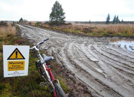
Back on the bike, I came to a gate where signs were posted on each side. One explained that tree-felling and forest track upgrading works relating to the Burn of Whilk Wind Farm were taking place on sections of the “core path” route. The other referred to “core path construction” which supposedly was commencing in March 2014 and was due to be finished by the end of the following month.
If this is a core path, I thought to myself as I surveyed the morass of rutted tyre-tracks and pools of mud stretching into the middle distance, I’d hate to see what a non-core path looks like.
I soon found myself in a churned-up landscape of forestry operations and wind farm excavation. Instead of a single trail, as outlined on my map, there was a confusing network of access tracks. It would have made a convincing set for a war movie: shredded woodland, trenches slicing through the dark earth, heavy machinery left unattended here and there, and big craters filled with watery brown gunge.
Basically I had to guess which way to go. Pushing on along what seemed to be the main access track, I encountered a gang of wind farm construction workers preparing a turbine base. Was I anywhere near the Camster cycle trail, by any chance? “No,” one of them replied. This track would eventually just take me back round the way I’d come – a frustrating U-turn.
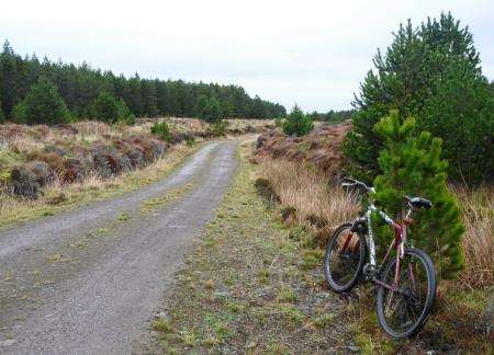
Another worker suggested I retreat for a bit and try an offshoot track rising up to a low ridge, past an unmanned digger. So I gave this a go, and to my relief it did lead on to the trail I wanted – although to get there I had to traverse one more mini-quagmire, this time with logs piled high on either side.
It felt great to be on a proper cycle trail at last. I whizzed along it and soon arrived at Camster.
Of course you can’t come here – another Historic Scotland site – without venturing into at least one of the two 5000-year-old cairns, Camster Round and Camster Long. I undid the bolt on the little gate at the first of these and crawled through the wet, gravelly tunnel before standing up in the centre where the interior is dimly illuminated by a skylight. Strange to think that burial rituals were taking place on this very spot about the time Stonehenge was being built.
A previous visitor had left a tea-light to burn out on a ledge inside the cairn. A sincere gesture, no doubt – communing with our Neolithic forefathers and all that. But it was merely litter now, so I stuffed it in my pocket and took it away.
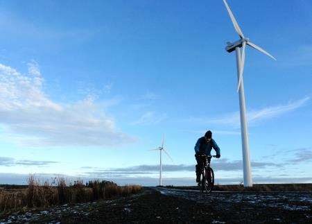
For thousands of years these twin monuments were the dominant man-made features for many miles around. Not any more. Just up the road, the Camster Wind Farm towers over the moorland and indeed some of the turbine blades can be seen from the boardwalk between the cairns.
It may not be the most sensitively sited renewable energy scheme, but at least it has opened up a more direct cycling route back to Wick. A well-made track takes you between the turbines, then through some more forestry, veering left to Achairn and then joining the Haster/Tannach road from which there’s a choice of routes back to Wick: a minor one over Newton Hill or the main Thurso/Wick road, the A882.
I opted for the latter, after a detour through Stirkoke that involved carrying the bike over a farm gate and squelching along one last soggy dirt-track. Well, I was caked in mud by now, and so was the bike, so a bit more of the stuff would do no harm.
* After this ride I raised the access issues with Matt Dent, Highland Council access officer for Caithness and Sutherland, who very helpfully made enquiries on my behalf; I understand the developer has now installed signs at the wind farm site indicating the core path route.